The Panama Canal is among the most popular cruise sites in the world, and deservedly so. Its fascinating history and spectacular size inspire, and its purpose is well served by tankers, cruise ships, and more on an almost constant basis.
A day going through the canal is filled with loudspeaker information on its construction and operation, but enjoyment of the passage can only be augmented with more knowledge of the canal’s history. One of the best books on the subject is David McCullough’s The Path Between the Seas, but for those seeking information without reading this or other lengthy books, what follows is a brief account of passage through this historic canal.
 Construction of the Panama Canal was started by a French group in 1881. The company, called Compagnie Universelle du Canal Interocéanique de Panama, was headed by Ferdinand de Lesseps, who gained fame building the Suez Canal. De Lesseps was not an engineer, as many presume, but a diplomat and promoter–some might compare him to a modern-day Wall Street investment banker. His zeal for the project, and inexperience in technical matters, got the project started with the backing of the French government. However, de Lesseps’ greatest skill was his charisma and the ease with which he was able to attract interest and financial support from the public by selling speculative shares in the canal project. This led to much the same situation that brought about the recent collapse in the U.S. stock market: de Lesseps undertook massive promotion to sell the project to investors, all the while underestimating costs, exaggerating progress reports to raise more money, and covering up when the project ran into trouble. The promotion was not unlike an internet IPO, starting fast and intensifying despite huge losses. In fact, after the French company unexpectedly went bankrupt in the face of inevitable failure, de Lesseps very nearly went to jail, escaping only because his health collapsed.
The reason behind the company’s failure was de Lesseps’ fixation on building a sea-level canal similar to the Suez Canal. The Suez Canal is in the flat desert where dredging at sea level was significantly easier than having to cross a small mountain range–as in Central America; plus the arid environment there was much more manageable that the damp, overgrown Caribbean jungle the French faced in Panama. Digging a canal where the French plan proposed required going over the Continental Divide, not high at the narrow Isthmus of Panama, but still at an elevation of 275 feet at its lowest point. To make the sea-level canal work meant cutting a central passage, wide enough for ships to pass, through the entire 275-foot wall of basalt rock. Further, particularly at the coasts, the ground was discovered to be extremely unstable, so that far more ground had to be removed than planned. On either side of the cut the land was high, making removal of slag and earth a major problem. A sea-level canal would have required moving so much rock and dirt that the job would have been nearly impossible.
As the French began, they had four principle problems: water, disease, faulty engineering, and irregular management. The digging started up the Chagres River, but there was so much rain, especially in a wet season, that men, equipment, and their work were often washed away in flash floods. Poor equipment made it nearly impossible to make reasonable headway on the project, in spite of the harsh climatic conditions, and the underused and too-light Panama Railway, which had potential to guarantee removal of earth as it was dug from the various pits along the main channel, did not even reach most of the active digging sites.
The problem of disease came from mosquitoes, which the wet weather made particularly serious. Hospitals had yet to draw a connection between mosquitoes and the spread of yellow fever and malaria. In an effort to rid themselves of insects in their facilities, hospitals took to placing dishes of water beneath bedposts and elsewhere, so infesting bugs would drown instead of making their way into patients’ sheets. This standing water, however, provided a perfect breeding ground for mosquitoes carrying much more deadly diseases than the other insects might have. While yellow fever and malaria spread rampantly through work camps, the hospitals themselves were notoriously thought of a “death traps”–a reputation that deterred even the sickest individuals from seeking medical help. Being assigned to the project as an engineer or supervisor became virtually a death sentence. Most of the labor was brought in from Jamaica, and death tolls ran in the tens of thousands. When the U.S. later went in to build the canal, the government of Jamaica refused to allow its people to go. (The U.S. recruited mainly in Barbados.)
Finally, the scattered management took a tremendous toll on the crews, contractors, and the project as a whole. Because of a combination of ill health, old age, inexperience, and lack of sufficient progress, the chief of the canal project–known as the “director general”–was replaced more than six times before the French company collapsed.
Slow progress played havoc with costs, engineering flaws virtually ensured the sea-level canal would not be built, disease ravaged the workers and management, and finally, after publicly raising funds several times, the company went bankrupt in 1889. More attempts were made to revive the French project, under different names, new companies, and more realistic designs, but by the turn of the century, the Panama Canal project was being woefully handed over to the United States.
Still, the French work was helpful when the Americans picked up the job and some of the huge dredges (many of which were American-made) they left behind turned out to be useful. But there is now only one remaining sign of the French work: as you enter the canal from the Atlantic side, looking to the left, the original French channel is still visible.
 The answer to the engineering problem that de Lesseps’ original team faced was actually in front of them the whole time. When the French government originally took bids on plans for the canal, one of the top engineers of the time–a man named Baron Nicholas-Joseph-Adolphe Godin de Lépinay–had suggested, instead of a sea-level canal like Suez, that they build an above-ground canal involving locks and artificial lakes for water transfer. A victim of his own pride, de Lesseps ignored this alternative suggestion and went ahead with his sea-level plan. When the Americans started work, they saw value in the notion of an above-ground canal. It was the best way. The idea was to make use of a tremendous amount of water by creating an artificial lake in the middle of the isthmus and a series of locks leading up to and away from that lake. Gravity would do all the work in filling and emptying the locks as needed, depending on the direction of travel.
The Americans still faced the problem of disease, but even that was eventually solved with the realization that mosquitoes were the carrier. Once this was understood, hospitals and camps were screened and every effort made to limit the accumulation of standing water. Disease was still a problem, but it was brought under control. In fact, mosquito control has been so intense for so many years that presently you will not see a single mosquito in the canal zone. While the mosquito as disease bearer was supposedly discovered in Panama, advanced medical experts connected with the Spanish American War had found the answer in Cuba about five years before, but the idea seemed so incredible that it was easily dismissed.
 At the time of the canal’s construction, Panama was not an independent country, rather it was part of Columbia. As the Americans became involved in the project, President Theodore Roosevelt supported the plan to keep the canal roughly where the French had started it, in Panama. There were many calls from Congress and the public to move the site to neighboring Nicaragua, where the project could be restarted with a clean record, but eventually–with the support of engineers, politicians, and business people–Roosevelt won out. When the Columbian government objected to the American presence in the region of Panama, sending troops to quash local support for the United States, the president encouraged and then formally supported a revolutionary group that created a new independent Panama in 1903. Roosevelt took his payoff in the form of a generous ten-mile-wide Canal Zone, which was administered entirely under the American government. When the original treaty expired in 1978, Jimmy Carter turned the zone back over to Panama, which now operates the canal exclusively (though Americans continued in a few supervisory rolls into the 1990s).
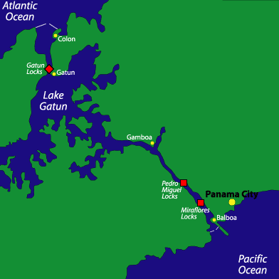
The under the Americans, the U.S. Army Corps of Engineers began work in 1904, and the canal was finished in 1914. The huge Gatun Lake was created by damming up both ends of the Chagres River, where locks are now located. The lake passage makes up the largest portion of the day-long trip through the canal, and is, in my mind, the least interesting part. Looking to the right going in from the Atlantic side at the Gatun locks, you will see a long stretch of high lake level land with waterfalls and a hydroelectric plant part way up. This is an earthen dam made from material drawn from the high ground; thus, it serves as both a dam and a disposal area.
 The greatest problem for the Americans was the cut–the high ground in the middle part of the isthmus (actually about three-quarters of the way through from the Atlantic side) at the Continental Divide. Going through the canal today, you will see walls somewhat higher than a cruise ship, reinforced with bolts and heavy screens. Originally the land was almost 200 feet higher at this point (bearing in mind that a boat floats roughly 83 feet above the lake bed). The plan was to make these walls steep, like the Corinthian Canal in Greece. Photographs taken at the Panama Canal’s opening reveal considerably higher walls than you will see today, but a tremendous slide closed the canal soon after it was officially opened. The ground at this point consisted of layers of slippery shale and a loose conglomerate that easily absorbed water and became mudlike, allowing the shale to slide much like snow and ice in avalanche conditions. Looking beyond the current walls, you can see that the land is fairly flat for a considerable distance. This land was originally much higher than in the cut itself, offering some idea of the huge amount of material that had to be removed to stabilize the area. The work was done like a large open pit mine, with terraced flat areas on which huge steam shovels picked up loads of earth and dropped them into railroad cars, the tracks being continually stretched and rebuilt as progress was made. That one of the original backers of the American plan to keep the canal site in Panama was also part owner of the Panama Railway Company is no coincidence. There were many such cross-interests among the canal’s management and supporters, which had the effect of making them even richer.
Shortly before the beginning of the cut (from the Atlantic side), lies the work town of Gamboa. Just beyond the town on the left, you will see a river coming into the canal. This is the relocated Chagres River, then as now the principle source of water to Gatun Lake. In order to better control the water supply, up this river about a mile is another dam, not visible from the boat. If Panama had a serious drought, the canal could become inoperative from the large volume of water let out each day from both ends.
 The canal is built with three all-together steps up at the Gatun Locks on the Atlantic side, and one- and two-step locks on the Pacific side, with the mile-long Miraflores Lake in between. There is a marina on the left-hand side, but not much else on this lake. As I understand it, Gatun Lake is very clear and beautiful once off the traffic path. It is a huge body of water, stretching back well away from the main traffic lane into many nooks and crannies.
As ships become bigger, there is a temptation to widen the canal by building another set of locks. While the canal itself is very profitable, the cost of such a project would be so great that it will probably never happen, despite Panama’s announced plans. Instead, on a worldwide basis, large ships are built to either go through the canal or not. The largest ships able to navigate through the canal are called “Panamax.” Anything bigger than these must find another way to move their goods across the isthmus. One alternative includes smaller cargo ships that operate almost exclusively within the canal, taking containers from terminals on either side. A number of large container ships may be passed during the passage, though generally traffic is all in one direction for half of each day. One interesting fact is that U.S. naval design has in part been determined by the width of the canal.
 The most famous feature of the canal is the system of trains operating on either side of the locks. The original concept for these trains was to pull ships through the locks while their engines were off. The fear was that a ship could get caught in gear, not be able to stop, and ram one of the gates, spilling out the water and closing the operation until the gate could be fixed and the water level raised. It’s easy to imagine this happening at the three-step Gatun locks, causing a massive flood of the entire lake rushing into the Atlantic. As an extra precaution, there were once huge chain brakes stretched across the locks. These precautions have now been eliminated. The chains are gone and ships get in and out of the locks under their own power. I suppose engines were less reliable in the old days, but today the risk of such an accident seems remote.
But the question remains, why are the little locomotives still there? The answer is, they always had second purpose: to keep ships locked in position as the water swirls rapidly in and out of the huge chambers. The cruise ships that daily go through the canal come very close to the canal’s side walls (cruise ships are also built with an eye to the Panama Canal). Given the great weight of these ships, considerable damage could be done both to the ship’s sides and to the canal walls. While operating the trains is obviously expensive, it is cheaper than having to constantly repair the canal, not to mention damage to the ships, and using bumpers, such as you see elsewhere, would strain the system by reducing the already precious width of the canal. I went through in a tandem lock with an oil tanker that just barely fit. It took much longer to get the ship in and out, and the process halted part way because one of the tanker’s sides had apparently struck the canal wall.
 As you come out to the Pacific, you pass under the soaring transcontinental bridge and then pass a breakwater on the left several miles long. This is the refuse from the Pacific-side construction. It is the largest and longest breakwater I have ever seen, and again reminds me of the immensity of the job.
One final feature that always interests me is the large number of ships waiting to go through at either end–a reminder of how important the Panama Canal remains today.
Leave a Reply