Category: Destinations

A growing list of information on destinations all over the world.

  • Egypt

    Eygpt FlagEgypt might be considered the world’s oldest tourist destination. With a plethora of cultural artifacts dating back thousands of years, and a long history of artistic, political, intellectual, and commercial milestones, the country and region have been attracting travelers since ancient times. The pyramids and tombs are not the only reason to visit Egypt. There is an extraordinary amount of art and architecture including relics from centuries of Greek, Roman, and Arabic occupation. All along the River Nile you can see different parts of Egyptian history that have survived thousands of years of cultural change and the rapid growth.

    But Egypt, like so many ancient lands, has entered the modern world paradoxically. Laborers often use the tools of their ancestors to farm, while the automobile traffic in the cities can be maddening. These contrasts are all over Egypt, and how much modernization Egypt accepts will ultimately effect the past, as well as the future of this great land.
    Traveling in Egypt
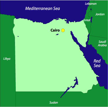
    Eygpt  Map Most flights connect to Egypt through European cities. Flying domestically in Egypt can be expensive, but there are trains, buses, and boats that will take you anywhere you want to go. Trains and buses can be extremely crowded because they usually wait until they cannot fit another body, before pulling away from the station. This may be uncomfortable, but it’s a great way to immerse yourself in the culture.

    Everyone traveling to Egypt is required to obtain a visa, avaible from Egyptian embassies worldwide. However, if you are from the United Stated, the European Union, Canada, or one of GCC countries, you can get a visa upon arrival at one of the larger airports, but you may want to deal with this beforehand, to avoid the trouble. Most visas last for one month, but they can generally be extended.

    Traveling in Egypt is cheap: most meals cost under US$5, good hotels can be found for under US$50 a night, many are under US$25.

    There are plenty of pickpockets around so it is a good idea to be extra careful with cash or valuables. Traveler’s checks are still a good way to carry cash as long as they are American Express or Visa. Credit Cards are accepted in some places, and there are ATM’s in larger cities.

    Gratuities are generally included in the bill, but you might double check to be sure. Haggling for items at the market and elsewhere is a way of life in Egypt, so don’t take anything at first glance–the cost of most products can be bargained down, including hotel rooms and other goods. A rule of thumb, when haggling, is never offer a price if you are not willing to pay it; if a shop keeper accepts your offer you, will be expected hand over the cash, pronto. Don’t bargain hunt if you’re not going to purchase–it could get you into trouble.

    Weather in Egypt
    South of Cairo, toward Luxor and Aswan, the blazing heat can be very uncomforable between June and August. However, this is also the most crowded time of year around the Mediterranean Coast. So when you choose to go depends entirely on what you want to do. The best time to travel south of Cairo is December to February. If you want to enjoy the north shore, March to May is the least crowded time when the weather will still be warm.

    Health Concerns in Egypt
    Bilharzia ranks second behind malaria as a public health concern in tropical and subtropical areas. You can get this disease through contact with infected water, and in Egypt, it is mainly found in the waters of the Nile.

    Diagnosing bilharzia is done by checking a patient’s urine or fecal matter. If you want to keep from getting this disease it is best to stay away from fresh water rivers and streams, especially near agricultural areas. For more information check out the following website: http: //www.who.ch/.

    Africa MapEgypt Information
    Population: 69.5 million
    Government: Republic
    Square Miles: 622,272 sq mi (1,001,449 sq km)
    Capitols: Cairo
    Languages: Arabic
    People: Berbers, Bedouins, and Nubians
    Religion: 94% Islam, 6% Christian
    Major products/industries: Oil & gas, metals, tourism, agriculture (especially cotton), and Suez Canal revenues

  • Australia

    Australia FlagAustralia is one of the world’s most unique natural habitats. Because it is isolated from most of the world, it has a wide variety of animals unique to its continent, and landscape that seems as impossible to live in as it is stunningly beautiful. It’s hard to justify trying to see all of Australia in just one trip. You will see some of the best beaches, experience some of the most inspiring wildlife, and meet among the finest people the world has to offer.
    The Australian Aborigines, have the longest continuous cultural history in the world, and were in Australia thousands of years before anyone else set foot on the continent.

    Europeans explorers came to Australia in the 16th century: first the Portuguese, then the Dutch explorers, and finally English pirate William Dampier. Captain James Cook sailed the eastern coast in 1770, on his famous voyage stopping at Botany Bay and literally running into the Great Barrier Reef. He claimed the continent for the British.

    In 1787, a fleet of 11 ships, 750 male and female convicts, and four companies of marines landed in Botany Bay. For the new arrivals, Australia was a harsh and horrible place; starvation was a constant threat.

    Traveling in Australia
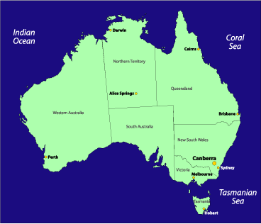
    Australia Map Australia’s climate differs a great deal depending on what part of the continent you are visiting. If you plan on staying in the southeast, near Melbourne or Sydney the climate is very nice year round. But up north in Queensland and the Northern Territory it can be brutal. The Australian continent is roughly the size of the United States; unless you plan to take a single long trip there, it will be difficult to see and do all that’s available to you. Focusing on specific parts of the continent is the best plan, so you get the most out of your experience. But don’t think that because you’ve seen Sydney, that you have seen Australia. That would be like going to New York City and saying you’ve seen the U.S. There’s a lot more to this beautiful land than its flagship city.

    Weather in Australia

    Much of Australia has great weather throughout the year, and there really isn’t a bad time to go. However, from December to February (Southern Hemispheric summer) it can be quite hot, and is best to be on the southern beaches. In the northern parts, in summer, it’s often wet and humid. The oceans to the north can also be unswimable due to the box jellyfish, which is one of many poisonous animal species in Australia.
    AustraliaAustralia
    Population:
    19.5 million
    Government:
    Independent member of the British Commonwealth
    Square Miles:
    2,966,200 sq mi (7,682,300 sq km)
    Capitol:
    Canberra (pop: 313,000)
    Official Language:
    English, Aboriginal languages
    People:
    94% European descent, 4% Asian, 1.5% Aboriginal
    Religion:
    75% Christian, 1% Muslim, 1% Buddhist
    Major products/industries:
    Minerals, oil, coal, gold, wool, cereals, meat

  • Montserrat

    Montserrat FlagMontserrat was once called the “Emerald Isle of the Caribbean,” a phrase coined by Columbus. It is graced with lush mountains and landscape crowned by three towering volcanoes. Unfortunately, one of those volcanoes–the Soufrière Hills volcano–erupted in 1995, making most of the island uninhabitable.

    Now, most of Montserrat’s residents live off-island–many having since relocated to Britain–while a very few remain in the less affected northern part of the island, or in emergency shelters, while waiting out the “storm.” Even with a volcano that continues to erupt periodically, tourists visit Montserrat, though certainly not in the number they once did.

    The capitol of Plymouth, with its Georgian-style houses and winding streets, now lays under many feet of ash.

    Montserrat MapSince the last major eruption, the governmental center of the island has been relocated to Brades near Carr’s Bay/Little Bay. But as of now, the island has no “cultural hub” like Plymouth was before the eruption. This can make finding provisions difficult since there is no major town center.

    The only people allowed into the restricted (read: dangerous) zone are scientists or people with business in that area. But there are many helicopter tours available to give you a bird’s-eye view of the southern portion of the island.

    Many locals who moved to England, Canada, or other British territories after the eruption are beginning to return and in the coming years Montserrat may again emerge as a major tourist destination, but for now it seems to only attract the courtesy of a few.

    If you are interested in visiting the island, it’s best to contact the tourist board for updated information.

    Traveling to/in Montserrat
    Montserrat VolcanoTo get to Montserrat you must fly to Antigua and either take a ferry or a helicopter charter to the island; the latter will prove to be a much more expensive route. The ferry ride takes about one hour, while the helicopter takes just twenty minutes. You can also arrive via helicopter from St. Kitts. To see the ferry or helicopter schedules click here.
    Once on island, the best way to get around is either by taxi or rental a car. You can also get a bus tour from one of the island’s tour companies.

    Weather in Montserrat
    Because of its location, the weather in Montserrat is almost always warm. The average high temperature throughout the year is around 80°F. The rainiest time of year is between June and December. Weatherwise, the least desirable time to visit is during hurricane season, which runs from June through October.

    Montserrat Information
    Population: 5000 (est. 2000)
    Government: Territory of the United Kingdom
    Square Miles: 39.5 sq mi (102 sq km)
    Capitol: Plymouth (mostly destroyed, August 1997)
    Brades, in Carr’s Bay/Little Bay (established after eruption)
    Official Languages: English
    People: African (90%), mixed descent (6%), European and East Indian (4%)
    Religion: Roman Catholic, Anglican, Methodist and other Christian denominations
    Major products/industries: tourism (until 1995), rum, textiles, electronic appliances

  • Solomon Islands

    Solomon Islands
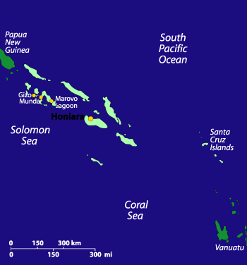
    Solomon Islands MapMillenia of immigration of Melanesians, Polynesians, Asians, Micronesians, and Westerners has made the Solomon Islands one of the most culturally rich island nations in the world. With thousands of small villages still espousing age-old beliefs and practicing ancient customs, locals are generally more than happy to allow you access to their land and entrance into their unique world, as well as help you find your way around the many small islands and vast lagoons that make the Solomons famous.

    Solomon Islands FlagTraveling to the Solomon Islands is not easy, with a troubled economic infrastructure, and fewer flights landing in its capital Honiara; however, the world-class scuba diving, fishing, snorkelling, and birding, as well as the colorful culture and the welcoming nature of the islanders makes this place very much worth a visit. Historically, interest in the Solomon Islands is focused on the role they played in the Pacific during World War II–the wreck-strewn waters of Iron Bottom Sound are testament to the strategic importance of the islands.

    Caution: Due to a rise in ethnic and economic tensions in the Solomon Islands, the U.S. and Australian governments have issued travel advisories against going to certain parts. Most visitors will attest that these tensions do not typically affect travelers; however, it may be worth investigating the region’s social and political situation before departing.

    Traveling in the Solomon Islands
    Because of their remote proximity to major regional air routes, the Solomon Islands remain quiet and unspoiled by tourism. Most of the hotels are located in the capital. Outside Honiara, facilities tend toward small hotels and basic village resorts. The Western Province offers spectacular lagoons and shallow coral reefs that are ideal for snorkeling and scuba diving.

    Inter-island transport is provided by Solomon Airline (the national airline) and Western Pacific (a privately owned local airline). During peak travel times–typically around the end of the year–it can be difficult to secure a seat without a booking several weeks in advance. Boat travel is available between all the islands, but because of the time it takes to traverse the waters between them, few visitors choose to use this method.

    Because the Solomons do not have a well-developed tourism infrastructure, it has remained comparitively pristine, both culturally and ecologically. For those willing to embrace the relative discomforts of travel in the islands, the experience is sure to be a rewarding one.

    The currency is the Solomon Islands dollar (US$1 = SI$3.5, approx.). Travelers checks can be exchanged in provincial capitals only, though it’s best to exchange traveler’s checks at a bank in Honiara before departing for other areas. Major credit cards are widely accepted in hotels and restaurants in Honiara, and at the larger hotels and resorts in the provinces. Tipping is not advised.

    Malaria risk is highest during the wet season. Mosquitoes avoid sprayed areas and come out mainly at dusk–so keep yourself sprayed, sleep under a sprayed mosquito net or in a screened room, wear long sleeves and trousers if you go out at dusk, and see your doctor before leaving for the Solomons for antimalaria medication.

    Weather in the Solomon Islands
    The climate in the Solomon Islands is tropical. Average daytime temperatures are around 85°F. Water temperatures are roughly 80-85°F. November through March tends to be hot and humid, with monsoon rains and the possibility of cyclones. April through October is drier and windy.

    Solomon Islands Information
    Population: 441,000
    Government: Parliamentary democracy
    Square Miles: 62,000 sq mi (1.35 million sq km); 10,750 sq mi (27,556 sq km) of dry land
    Capitol: Honiara
    Official Language: Solomon Islands Pijin, English and 67 official indigenous languages
    People: Melanesian (95%), Polynesian (4%), Asian and Micronesian (1%)
    Religion: Christian denominations (96%)
    Major products/industries: Timber, fish, palm oil

  • Panama

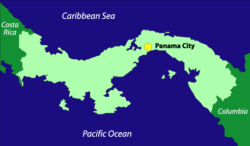
    Panama MapPanama has a checkered past, but as a modern country it runs one of the world’s most important waterways, the Panama Canal, and has built for itself a large offshore investing business. From its capitol at Panama City to its rainforests and rich coastlines, Panama is a beautiful land, but it suffers from increasing crime and an uncertain government.
    Panama is a proud and striking nation with a population of seven indigenous groups and a strong Spanish legacy. And it’s is a wonderful place to travel, as long as you’re careful and conscious of your surroundings.

    If you want to see Panama at its cultural best, Carnaval is celebrated the weekend before Ash Wednesday in Panama City. It’s one of the largest and most vibrant Carnaval celebrations in the world.

    Traveling in Panama
    If you are an American, Japanese, New Zealander, or Venezuelan citizen, it is required that you have a tourist visa or tourist card to enter Panama. You should contact your embassy or consulate for details.

    While traveling in Panama is considerably cheaper than traveling in the United States, for instance, it will also tend to be pricier than most other Central American countries. Expect to pay about US$20-30 per day, on a moderate budget, for Panama Mapfood, accommodations, and other expenses. A budget traveler can find room and board for as low as US$10-15 per day. The Panamanian currency is called the balboa, but it’s exactly the same as the U.S. dollar, from the rate of exchange (which is unnecessary if using U.S. currency) all the way to the bills they use. Even the coins are the same shape, weight, and substance as U.S. coins. Exchanging other types of currency can be easily done at a casa de cambio, of which there are many throughout the small nation.

    Tipping 10% of your bill can be done at finer restaurants; however, it’s not necessary at more casual establishments, such as cafes. Haggling over goods is not customary in Panama.

    Health Risks in Panama
    Health risks include dengue, hantavirus, malaria, rabies, and yellow fever. It is advised that you consult a doctor about what shots you may need before traveling to Panama.

    Weather in Panama
    The best time to go to Panama is during the dry season, between December and April. During the rainy season the weather can be humid, damp, and very uncomfortable, especially if you take part in strenuous activities like hiking, etc. The rain in Panama typically comes in short downpours that have a cooling and cleansing effect on the air.

    Panama Information
    Population: 2,800,000
    Government: Constitutional Republic
    Square Miles: 30,420 sq mi (78,000 sq km)
    Capitol: Panama City (pop: 700,000)
    Official Languages: Spanish, English, and Native languages
    People: 65% mestizo, 14% African descent, 10% Spanish descent, 10% Indian
    Religion: 85% Roman Catholic, 10% Protestant, 5% Islamic
    Major products/industries: Banking, construction, petroleum refining, brewing, cement and other construction materials, sugar milling, shipping, and agriculture

  • Scotland

    Scotland FlagAncient history melds with cutting-edge technology; long, rainy, or freezing winters contrast against vibrant, endless days of summer. Such are the complexities of Scotland, a land where the gloomy weather very often belies the sunny dispostion of her people.

    “Wherever I wander, wherever I rove, the hills of the Highlands for ever I love,” wrote Robert Burns, Scotland’s National Poet, and true enough, the Scottish Highlands have captured the hearts of many. This rugged land is defined by its jagged mountain peaks, verdant valleys, icy lochs, and imposing solitude. It’s a place meant for relflection and with all the solitary activities to take on in the Highlands, it’d be hard not to spend some quality time looking in at yourself. Fishing and hiking are two of the most popular pastimes. The rivers and lakes are filled with trout, and an afternoon of casting flies while waist deep in frigid water (with waders of course) is enough to have you heading to the pub come evening for a pint and a bite. There are marked hiking trails all over the highlands (the West Highland Way, for instance, will take you from Stirling all the way to the base of Ben Nevis–the tallest mountain in Britain–in the town of Fort William), but you don’t need a trail marker to give you permission: rights of way on private land for walkers is a tradition still followed in many parts of Britain. You shouldn’t have too much trouble tramping across a field here and there. Or for a little more social activity, grab your clubs and hit the links. Scotland is perhaps most famous for being the birthplace of golf; anybody can get a tee time at the Old Course in St. Andrews, but beware: their next opening may not be for many months.

    Scotland MapHead out to the west coast and have access to many of the western isles. Mull is a short ferry trip away from the coastal town of Oban and offers good walking trails and the quaintness of its fishing port Tobermory, without having to travel far from the mainland; others like Islay and Coll are more desolate, with walking trails, castles, distilleries to tour (and taste from), and picturesque scenery. The Isle of Skye, further north and connected to the mainland by a bridge, is larger and more diverse, with small towns like Portree offering a few shopping oportunities, and a dramatic landscape from the rocky Cuillins down to the sea. For even more peace and quiet, make your way to the Outer Hebrides where island names like Harris and Lewis represent the superlative in stark beauty: mountains, moors, beaches, and more, and very few people to distract you. Or head to the far north to the Orkney or Shetland Islands, both known for their prehistoric artifacts (such as Skara Brae on Mainland Island) and diverse bird life. The Shetland Islands were, until 1469, under Norse rule, and the Scandinavian heritage still runs strong there. It is perhaps the most remote region of Scotland from that point of view.

    Scotland LandscapeBut Scotland isn’t just for escaping. The cities have lots to offer as well. Edinburgh is a thriving metropolis, banking and academic center, and home to the Royal seat in Scotland–the Palace of Holyroodhouse. There are a number of notable museums, such as the Scottish National Portrait Gallery and the National Gallery of Scotland, as well as unique and beautiful parks like Calton Hill (home to a number of Scottish monuments), Arthur’s Seat at Holyrood Park, Edinburgh Castle, and the Royal Botanic Garden. Take a stroll down the Royal Mile or through New Town and you’ll find pubs, shops, restaurants, and accomodations that will suit your mood. Glascow is a very different kind of city. This one-time shipbuilding capitol has weathered the storms of recession and come out the other side with a fresh, new perspective. Glascow is known for its art, design, and architecture. It’s a decidely more modern city than Edinburgh, and as such, it attracts a great deal of younger people. Make your way to Sauchiehall Street for all of your shopping, eating, and drinking needs; but don’t miss the history that Glascow has to offer too. In the eastern part of the city you’ll find the gothic Glasgow Cathedral, St. Mungo’s Museum of Religious Life and Art, and Provand’s Lordship (built in the 15th century, it’s the oldest house in Glascow). Another interesting attraction is the Tenement House museum–offering a window into middle-class life around the turn of the 20th century.

    Traveling in Scotland
    Traveling in Scotland is typically less expensive than in England (and certainly less than London). The cities are costlier than the countryside, but rates will rise significantly in the Highlands and Islands due to their inaccessibility. Scotland has its own currency, but the pound stirling is accepted everywhere (just as the Scottish pound is generally accepted in England). Accessing funds in Scotland shouldn’t be a problem as traveler’s checks and credit cards are widely excepted, and ATMs are abundant.

    The summer is when most people visit Scotland. Summer days are very long and, on the whole, drier than winter days. Also there are a number of festivals and attractions in the summertime, such as the Edinburgh Festival and Fringe Festival in August and September (a word of warning: accomodations in the city and neighboring areas are booked often a year in advance of these festivals; if you want to go to Edinburgh during this time, you have to plan early). But winter has a lot to offer as well. Skiing is fast becoming a major sport in the Highlands, and other outdoor adventure sports, like ice climbing, are popular. The New Year (or “Hogamanay”) ushers in a seriously fun celebration that can turn the biggest city or the smallest town into a chaotic mass of revelers.

    Weather in Scotland
    Weather in Scotland can be very grim–it’s true–but the bright side is, it’s beautiful in the rain, and even more beautiful in the sun. The dampness can feel everpresent and farther north, rain turns to snow in the winter. The worst time to visit Scotland, weatherwise, is definitely in the winter. The sun barely comes up (don’t be fooled by the relative warmth provided by the Gulf Stream; Scotland is very near the Arctic circle), and the clouds linger and drip. The best times are between April and September–the weather is warmer and drier then, and most commercial operations are open…and in the north, in the summer, the sun barely goes down.

    Scotland Information
    Population: 5.1 million
    Government: Parliamentary Democracy
    Square Miles: 30,414 (78,772 sq km)
    Capitol: Edinburgh (pop 408,000)
    Official Languages: English, Gaelic
    People: Celts, Anglo-Saxons
    Religion: Presbyterian Church of Scotland, other Presbyterian churches, Anglicans, Catholics
    Major products/industries: Banking and finance, steel, transport equipment, oil and gas, whisky, tourism

  • South Africa

    South Africian FlagAs apartheid and all that it represents becomes a thing of the past in South Africa, much of the country is moving forward with rejuvenated ideas, interests, and fair politics. And tourists are flocking back to South Africa in droves. Many of the dangers of traveling to this country have gone by the wayside: political violence is down, and with certain notable exceptions, touring the country is safer and more pleasurable than it was for much of the second half to the twentieth century.

    Traveling in South Africa
    South Africian Map For the uninitiated in Africa, South Africa is a pretty good place to get your feet wet. As the government organizes in the post-apartheid environment, infrastructure improvements and ease of travel have taken great strides forward. The climate is generally mild and–with many national parks and eco-safaris available–South Africa is a fantastic place to view wildlife. However, there’s a lot about this country that still smacks of the Dark Ages: poverty continues to exist in its rawest form, AIDS has overrun the population, and random violence remains a problem. As always, it’s best to use common sense when it comes to traveling safely, but be sure to take an extra measure of precaution in crowded public places such as train and bus stations, shopping bazaars, major cities, etc. Keep your money out of sight and in a place where it’s not easily accessible to pick-pockets, be wary of potentially dangerous situations, and go to South Africa with the understanding that it continues to be a society in flux.

    Weather in South Africa
    Summer can be quite hot, particularly in the lowveld (coastal plain). High-altitude areas are pleasantly warm over summer, but the mountains are prone to rain. The northeastern regions can be humid, but swimming on the east coast is a year-round activity. Springtime is the best time for wildflowers in the northern and western Cape provinces. Winters are mild everywhere except in the highest country, where there are frosts and occasional snowfalls.

    Mid-December to late January is vacation time for South African city dwellers. Resorts and national parks are heavily booked and prices on the coast can more than double during these months. School holidays in April, July, and September can also add congestion to beaches and national parks.

    Visas for South Africa
    Entry permits are issued free on arrival to visitors on holiday from many Commonwealth and most Western European countries, as well as Japan and the United States. If you aren’t entitled to an entry permit, you’ll need to get a visa (also free) before you arrive.

    Health Concerns in South Africa
    Malaria is mainly confined to the eastern half of South Africa, especially on the lowveld. Bilharzia is also found mainly in the east but outbreaks do occur in other places, so you should always check with knowledgeable local people before drinking water or swimming in it. AIDS is a major problem throughout Africa, and South Africa is no exception, with upward of 20% of the total population infected. While it is common knowledge to much of the Western world that HIV can only be transmitted through sexual contact, shared intravenous needles, or blood transfusions, in South Africa, only recently have efforts gone underway to educate the people. It’s always a good idea to be aware of such pandemics as you enter a country, for reasons of protecting yourself, as well as gaining a better understanding of the culture and environment.

    Cash in South Africa
    It’s very possible to spend just US$10 per day, if you’re willing to camp or stay in hostels. Arranging public transport can make this number considerably higher, and some of the more daring souls choose hitch-hiking, in favor of bussing, flying, or taking the train.

    If you’d rather have the privacy of a solo hotel room, eat in restaurants, and tour the country by bus or train, expect to spend roughly US$40-60 per day.

    Tipping is expected because of low wages. Roughly 10%-15% is the norm.

    South Africa Information
    Africa MapPopulation: 43.1 million
    Government: Republic and independent member of the British Commonwealth
    Square Miles: 1,221,037 sq km
    Capitols: Pretoria (administrative), Bloemfontein (judicial), and Cape Town (legislative)
    Languages: Zulu, Xhosa, Afrikaans, Pedi, English, Tswana, Sotho, Tsonga, Swati, Venda, Ndebele
    People: 77% black, 10% white (60% of whites are of Afrikaner descent, most of the rest are of British descent), 8% mixed race, 2.5% of Indian or Asian descent
    Religion: Christian, Muslim, Hindu, Jewish and traditional religions
    Major products/industries: Mining, finance, insurance, food processing

  • Canada

    Canada FlagJust because Canada borders the U.S. doesn’t mean it is like the U.S. The eastern parts of Canada, such as Quebec and Ontario, are modern and sophisticated; while the west and north are still somewhat wild, and often seem untouched compared to the United States and Europe.
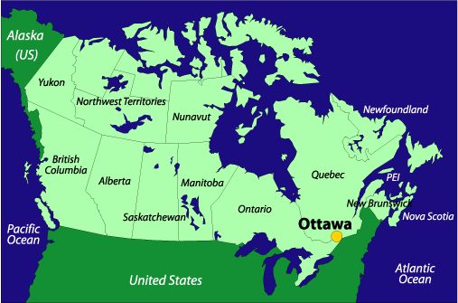
    Canada’s population is an amalgam of indigenous people; descendent’s of French and British colonists who came to explore, trap, fish, and more; and in the west, a fast growing population of Asian émigrés. And with the vast majority of the country’s population residing near the southern border, there is a huge amount of land to the north that remains almost uninhabited.

    Traveling in Canada
    Canada MapCanada has a little bit of everything, from thriving metropolises (such as, Montreal, Toronto, and Vancouver) to the wild open territories of the northern provinces. The major cities range from being centers of culture, trade, and population, to gateways to the outdoors, cultural melting pots, immigration centers, and more.

    The land in central and northern Canada is perfect for adventure travel like skiing, fishing, camping, hiking, rafting, rock and ice climbing, hunting, and more, as well as for the mining and logging industries that have set up camp there.

    In the past decade, the native population of Canada has gained a much stronger voice in Parliament, which has led to growth in the regions they control; but don’t let that fool you: outside of the cities, the population is spare and the wilderness is open. Canada’s national park system is extensive, and park rules, in many ways, favor the wildlife over human visitors (for example, protection from bears, in many parks, is limited to using common sense when camping–even items like bear spray are discouraged or illegal, and guns for protection are strictly forbidden).

    Weather in Canada

    Spring, summer, autumn, and winter are all ideal for tourism in much of Canada, but keep in mind that the cold weather comes early and leaves late in the northern and noncoastal areas. Skiing is great, especially in the Canadian Rockies, and the season lasts from December through April. If you want to camp, hike, river raft, or enjoy other water activities on Canada’s lakes and rivers, the best time is the summer because in the shoulder seasons certain facilities could be closed.

    For very adventurous travel (for example, to the Arctic interior), we’d suggest either going with friends who know the area well and have experience in all types of extreme environments, or signing on with a professionally guided trip, with whom you’ll hopefully meet interesting people and get the most well-rounded experience available. But bear in mind that guiding companies often sell trips months or even years in advance–sign up early and plan a lot, and you’ll certainly have a great time.

    Canada Information
    North / Central AmericaPopulation: 31,280,000
    Government: Parliamentary democracy
    Square Miles: 3.9 million sq mi (9,976,000 sq km)
    Capitol: Ottawa (pop: 1,010,500)
    Official Language: English, French, and native languages
    People: British descent (28%), French descent (23%), Italian descent (3%), aboriginal peoples (2%)
    Religion: Catholic (45%), Protestant (36%), and minorities from most of the world’s major religions
    Major products/industries: processed and unprocessed minerals, food products, wood and paper products, transportation equipment, chemicals, fish products, petroleum and natural gas
    Health risks: Cholera, dengue fever, hepatitis, malaria, yellow fever

  • St. Lucia

    St. Lucia FlagSt. Lucia, which is one of the bigger islands in the Windward Island chain of the lower Caribbean, has done what most of the Caribbean islands have done after the tapering off of their once rich agriculture and exports industries: turned itself over to tourism. After the sugar industry collasped the islands of the Caribbean struggled to get by until airplane travel made visiting these once remote outposts just a few flight connections away. There are still some old fishing villages mixed in among the resorts and charter sailboat operations, but the main industry now is tourism and service.

    That doesn’t mean that St. Lucia–with its high volcanic mountains–isn’t still a beautiful island. It has not yet been ruined by overdevelopment, and you continue get the special feel of its laid-back, if rugged, environment once you leave the craziness of Castries, the capital. There is plenty to see in St. Lucia, from towering peaks called the Pitons, to its wonderful coastline with so many picturesque beaches. This island has much to offer as long as the resort developers keep their distance.

    Traveling in St. Lucia
    St. Lucia MapGetting around St. Lucia is easy, unless you’re not used to driving on the left-hand side of the road: because it’s a member of the British Commonwealth, British traffic rules apply.

    Flying in and out of St. Lucia is a little more complicated. The small island has two airports, the older Vigie Airport in the north, near the capital, and the newer Hewanorra International Airport in the south, near the town of Vieux Fort. If you are flying in, it may be a good idea to choose the airport in relation to where you’ll be staying.

    Health Risks in St. Lucia
    Besides a poisonous viper (called the fer-de-lance) that inhabits the island, the only major health risk is Bilharzia (schistosomiasis), an infection caused when you come in contact with contaminated water. This happens mainly in fresh water ponds, lakes, and rivers. You can avoid this by swimming in protected (chlorinated) swimming pools or the salt water ocean–which is, of course, why many people come to St. Lucia. For more information, contact your doctor or read about Bilharzia at about.com.

    Weather in St. Lucia

    Because of its location, the weather in St. Lucia is almost always warm. The average high temperature throughout the year is right around 80°F. The rainiest time of year is between June and December.

    St. Lucia Information
    Population: 156,260
    Government: Independent republic within the British Commonwealth
    Square Miles: 240 sq mi (616 sq km)
    Capitol: Castries (pop 50,000)
    Official Languages: English and French-based patois
    People: African (90%), mixed descent (6%), European and East Indian (4%)
    Religion: Roman Catholic (90%), Protestant (7%), Anglican (3%)
    Major products/industries: Bananas, coconuts, cocoa, assembly of electronic components, clothing, tourism

  • El Salvador

    El Salvador FlagTo understand more about this troubled Central American country one only needs to watch the movie Salvador, about the brutal civil war that tore the country apart in the 1980s. The civil war is now over in El Salvador, and its beauty and splendor–including active volcanoes and cloud forests–are starting to show again.

    Traveling in El Salvador isn’t like in other Central American countries, where independent travel is the norm. Currently, most people come to El Salvador to participate in the redevelopment and restoration of this post-war country. Organizations from all over the world bring people here to help with education, healthcare, and other initiatives that will put El Salvador on the road to recovery.

    A recent blow to El Salvador’s revitalization, a massive earthquake hit the region in early 2001 causing a state of emergency. Not all the areas of the country were affected, but the area around the capitol San Salvador suffered greatly, and much is still needed to be done to help El Salvador recover from this latest tragedy.

    Traveling in El Salvador
    El Salvador MapThe 2001 earthquake disrupted all travel in El Salvador, so public transportation in the country is unpredictable. Some raods are still washed out so there is no way to tell how easy it is to travel around the entire country. But there is a good bus system, and if the roads are open, buses will run frequently. Renting a car is also possible, but it is best to discuss with someone first where you are headed so you know how the road is or if it’s passable.

    U.S. and Canadian citizens do not require a visa but must buy a tourist card–valid for 90 days–upon arrival. Citizens of Australia and New Zealand need a visa; citizens of most Western European countries do not require a visa or tourist card.

    Health Risks in El Salvador
    Health risks include cholera, dengue fever, malaria, hepatitis, typhoid, and dysentery. It is advised that you consult a doctor about what shots you may need before traveling to El Salvador.

    What to Know
    In 2001, the U.S. dollar became the official currency in El Salvador, but places still accept the old currency the colón. Things are more expensive here than in other Central American countries, but it is still comparatively cheap for most travelers–$25 to $30 dollars a day will get you reasonable accomodations and meals.

    Weather in El Salvador
    The optimal time to visit is the dry season, which is from November to April. The roads are in the best condition and most of the cultural festivals take place during this period. But during the main festival season, as well as before Easter and after Christmas, traveling is most expensive. The wet season–May to October–can still be nice, but expect daily rain showers.

    El Salvador Information
    North / Central AmericaPopulation:6,122,515
    Government: Republic
    Square Miles: 8093 sq mi (20,752 sq km)
    Capitol: San Salvador (pop 1 million)
    Official Languages:Spanish
    People: 94% mestizo (Spanish-Indian), 5% Indian, 1% European descent
    Religion: 75% Roman Catholic, 20% Protestant
    Major products/industries: Textiles, coffee, sugar, beverages, petroleum, chemicals, fertilizer, textiles, furniture, light metals, cotton