Category: Destinations

A growing list of information on destinations all over the world.

  • Iraq

    Iraq FlagMuch of early history centers itself around an area known as the “Fertile Crescent,” referring to the land between the Tigris and Euphrates Rivers in present-day Iraq. Many ancient kingdoms were borne out of this region, including the Assyrians, Sumerians, and Babylonians–whose legendary King Hammurabi penned the enormously important Code of Hammurabi, one of the most significant legal doctrines of all time.

    Much later this region was part of the Ottoman Empire, until 1932 when Iraq became an independent kingdom. Traveling to Iraq has not been appealing to most people in recent years; the country has been part of a series of wars dating back decades–first with their neighbor and foe, Iran; then with the United States after a failed attempt to gain control over another neighbor, Kuwait. Currently, the U.S. government and the governments of several other nations are extremely focussed on removing the despotic dictator Saddam Hussein and his regime. This has led to large-scale military action between Iraq and much of the outside world.

    Economic sanctions and internal mismanagement have essentially ruined the Iraqi economy, food shortages have reached devastating levels, and the threat of war has all but guaranteed that Iraq won’t develop into a tourist destination in the foreseeable future.

    For the present, it is our contention that–barring extreme circumstances–traveling to Iraq should be avoided at all costs. Particularly for Westerners, it is considered very unsafe.

    Traveling in Iraq
    Iraq MapFor those brave enough to travel to this war-torn and tumultuous nation, getting in is the hardest part. Due to war-related restrictions, there are no commercial air carriers running flights to Baghdad’s international airport. By road, borders with Turkey and Jordan are heavily guarded. Internal and cross-border struggles with the Kurdish population make many outlying regions dangerous. And internal violence between allied Western troops and local Iraqi militia pose a threat to just about everyone.

    Weather in Iraq
    The weather in Iraq is very arid and the country gets little rainfall. The hottest season in Iraq is between May and September. In Bagbdad the temperature in summer can reach 123°F (51°C), but averages about 95°F (35°C). In the winter it gets down to a temperature average of 50°F (10°C).

    Iraq Information

    Population: 24,001,816 (2002 est.)
    Government: Republic
    Square Miles: 169,235 sq mi (438,317 sq km)
    Capitol: Baghdad (pop. 5 million)
    Official Language: Arabic (official), Kurdish
    People: 79% Arabs, 16% Kurds, 3% Persians, 2% Turks
    Religion: Shia Muslim (65%), Sunni Muslim (30%), Christian (3%)
    Major products/industries: Oil, natural gas, agriculture, fishing

  • Papua New Guinea

    Papua New Guinea FlagPapua New Guinea Flag Papua New Guinea makes up the eastern half of the island of New Guinea–the second largest island in the world. It was divided between Germany (north) and the U.K. (south) in 1885. The latter area was transferred to Australia in 1902, which occupied the north during World War I and continued to administer the combined areas until independence in 1975.

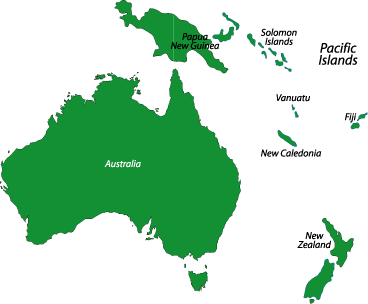
    Papua New Guinea MapPapua New Guinea has vast natural resources, but exploitation of them is difficult due to rugged terrain and the high cost of developing an infrastructure. Agriculture provides a subsistence livelihood for most of the population, while mineral deposits, such as oil, copper, and gold, account for a large part of export earnings.

    Wildlife diversity, varied landscape, primeval indigenous communtities, and pimordial forests and mountains excite adventure travelers around the globe. However, years of bad press–some exaggerated, some not–relating to ethnic and racial conflict, as well as extreme poverty and violent crime, are cause for concern among tourists. Take the necessary precautions before going to Papua New Guinea, but enjoy it for all that it has to offer.

    Traveling in Papua New Guinea
    Australia Oceania MapPapua New Guinea is a country so raw and untamed it attracts adventrous travelers the world over. But Papua New Guinea also suffers from major unemployment, terrible crime, and exploitation. Because of this the tourism industry is quite new and has limited infrustruture for dealing with visitors. This can make Papua New Guinea a dangerous place to travel, and for all of its beauty, there is also real danger in traveling there. If you are planning a trip to Papua New Guinea it’s wise to follow a few guidelines. First, it’s best not to travel at night; this goes especially for wandering around after dark. You should also dress conservatively so not to draw attention to yourself. It’s smart to listen to local advice and make friends with the locals around the area you are visiting, but the best advice is to be cautious and aware of your surroundings.

    Flying to Papua New Guinea is the easiest way to get there. Most flights leave from Australia, but you can also catch flights from other places such as Singapore, Manila, and Guam. Most flights go to Port Moresby, but there is also an airport in Alotau.

    The best way to travel around the country is by flying. The main carrier–Air Niugini–has flights to small airstrips scattered around the country. There are roads around the country, but because of the terrain they are limited. There are public transportation systems (PMVs) which travel around a pre-established route; they are cheap and will drop you off anywhere along the route. Renting a car is not a good option because local tribes can take serious, and sometimes deadly, actions against drivers who get into accidents. You can also travel by boat, but this can be uncomfortable and unreliable.

    Weather in Papua New Guinea
    Papua New Guinea has a hot, humid, and wet climate year round. The “defined” seasons are as follows, December to March is the wet season and May to October is the dry season. But annaul rainful in different areas ranges from 39 inches to an amazing 20 feet. The temperatures on the coast range between 77° and 86°, but in the highlands the temperatures can be very chilly.

    Papua New Guinea Information
    Population: 4.5 million
    Government: Democracy
    Square Miles: 180,508 sq mi (462,840 sq km)
    Capitol: N’Djamena (pop 700,000)
    Official Language: 750 indigenous languages plus Pidgin and Motu
    People: 95% Melanesian, 5% Polynesian, Micronesian, Chinese
    Religion: 44% Protestant, 22% Catholic and 34% pantheistic beliefs
    Major products/industries: Coffee, copper, gold, silver, copra crushing, palm oil processing, logging

  • Costa Rica

    Costa Rica FlagCosta Rica has long been seen as an “eye of the hurricane”–a peaceful nation situated in the center of an often turbulent region. The rich history and well-preserved and diverse environment attracts tourists from around the globe. From its beautiful beaches to its massive rainforest, teaming with wildlife, the Costa Rican government has long been committed to preserve the country’s reputation as a environmentally and user-friendly place to visit.

    Traveling in Costa Rica
    Because it’s the transportation hub for international visitors, most people spend a couple of day in the capitol city San José for at least a couple of days. Compared to other Central American capitols, San José is more metropolitan and modern, with finer restaurants, nice hotels, shopping malls, a variety of museums, and more. But if you’re travelling on a budget, don’t let the polish of San José deter you. It’s possible to eat, sleep, and enjoy all that Costa Rica has to offer, for as low as US$20-$30 a day.

    If using traveler’s checks, stick to U.S. dollars. American cash is the most easily exchanged, but it’s recommended you use small, newer bills, as countefeiting is widespread. Restaurants typically add a 10% gratuity to the bill, so tipping here is unnecessary unless the service is exceptional. It’s recommended, however, that you tip bell boys, room attendants, and tour guides.

    Costa Rica MapThe Caribbean coast is home to many of the more popular beaches and most of the protected environmental area in Costa Rica. The wildlife here is plentiful–including the hanging sloth and breeding grounds for green sea turtles–and it’s also the most culturally diverse part of the country, with plenty of handicrafts, music, and cultural tours to be had. If you’re looking for a little quiter action, head to the Pacific coast, where more remote beaches, parks, and destinations can be found on the Península de Nicoya and elsewhere. One of the nicest beaches in Costa Rica is Playa Sámara, and Montezuma, near the tip of the Península de Nicoya.

    Weather in Costa Rica
    The dry season in Costa Rica is between late December and April; the wet season lasts the rest of the year; however, the Caribbean coast tends to be wet year round. As a tropical country, temperatures vary little between seasons, affected most by altitude. San José, at 3772 feet, has a climate that the locals refer to as the “Eternal Spring”: lows average 60°F (15°C) and highs average 79°F (26°C). The coasts tend to be much hotter, with the Caribbean from the 70s to the high 80s (°F) day to night. The humidity at lower altitudes can be oppressive.

    Republic of Costa Rica Information
    North / Central AmericaPopulation: 3.8 million
    Government: Democratic
    Square Miles: 19,929 sq mi (51,100 sq km)
    Capitol: San José (pop: 340,000)
    Official Languages: Spanish, Creole English, and Indian dialects
    People: 96% Spanish descent, 2% African descent, 1% indigenous Indians, 1% Chinese
    Religion: 85% Roman Catholic, 14% Protestant
    Major products/industries: Tourism, electronics, coffee, bananas, sugar, food processing, textiles and clothing, construction materials, fertilizer, plastic products

  • Venezuela

    Venezuelain FlagVenezuela is a gloriously beautiful country, and with almost 2000 miles of coastline, mountains, and jungle, there is something for everyone. Sites like Angel Falls, the world’s highest waterfall, and Lake Maracaibo, South America’s largest lake, ensure that you won’t soon forget Venezuela’s natural beauty. This is a country of extremes–just check out the giant anaconda for proof; it’s the world’s longest snake, capable of devouring a 100-pound tapir, or even a human, in a single meal.
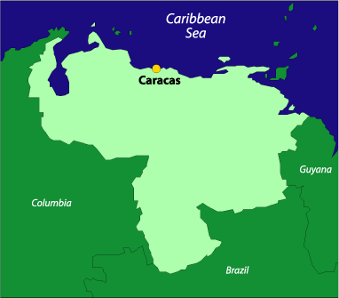
    Traveling in Venezuela Venezuela
    Venezuela’s government is in a state of disarray after the recent ouster, then quick reinstatement, of President Hugo Chavez. The situation in Venezuela continues to be unstable, and growing guerilla violence along the Columbian border only makes things worse. The United States, among other countries, has issued warnings to its nationals who plan to travel in Venezuela: it can be risky, and it’s best to contact your embassy for information and use caution if you decide to go.

    Weather in Venezuela
    The country’s climate is mostly tropical, temperatures range between the low 60’s and 90-degree range, depending on where you are. The verano, or summer dry season, lasts from December to April, and the invierno, or winter wet season, is from May through November. The dry season is the best time to travel in Venezuela, especially if you are planning outdoor activities such as hiking or beach activities along the Caribbean coast. Weather in the Amazon rainforest is, as expected, uniformly wet with no distinct seasons. Any excursions into the rainforest or on other major treks demand an experienced guide and familiarity with the environment (not to mention a sharp machete to clear your trail).

    South America Venezuela Information
    Population:
    24,000,000 (est.1994)
    Government:
    Federal Republic
    Square Miles:
    355,700 sq mi (912,050 sq km)
    Capitol:
    Caracas (pop 4,608,934)
    Official Language:
    Spanish
    People:
    67% mestizo, 21% European descent, 10% African descent, 2% indigenous.
    Religion:
    96% Roman Catholic, 2% Protestant
    Major products/industries:
    Petroleum, iron ore, cereals, fruit, sugar and coffee
    Health risks:
    Cholera, dengue fever, hepatitis, malaria, yellow fever

  • Belize

    Belize FlagCompared with the rest of volatile Central America, Belize is more like the island nations of the eastern Caribbean than it’s mainland neighbors. Its laid back way reminds visitors of the way the Caribbean was in the days before the big resorts.
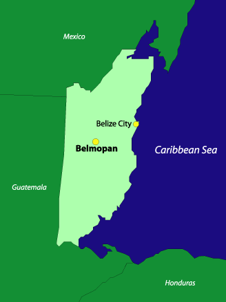
    With only three major paved highways, traveling through Belize is truly an experience. But those same roads will take you to spectacular Mayan ruins in pristine jungles, secluded and peaceful ecotourist lodges, and some of the best scuba diving in the world.

    All this is not cheap: hotels are few and far between–and thus, more expensive than in other Central American nations. But this lack of sprawling accommodations makes traveling in Belize like stepping back into a simplier time. If you like an adventurous travel destination, Belize might be just the place for you.

    Traveling in Belize
    Belize MapWith few paved roads and no trains, traveling in Belize can be tough. Small airplanes travel from Belize City and other cities and towns throughout the country. Cars can be rented but after heavy rains, travel can be nearly impossible as the roads get washed out. If you are headed to the coast or islands, there are frequent launches to most of these places.

    Belize can be expensive compared to the rest of Central America. But it is still vastly cheaper than many of the islands of the Caribbean. Midlevel rooms will go for roughly $15-$25 a night; higher-end hotels, however, will not be unreasonably expensive. Meals are quite reasonably priced, and you could get away with staying in Belize for under $30 a day, not including transportation cost.

    American and Canadian dollars, as well as pounds stirling, are easily exchanged in Belize, and most major credit cards are widely accepted. One important thing to remember, though–ATM machines in Belize will not accept foreign bank cards.

    Health Risks in Belize
    Health risks include cholera, dengue fever, malaria, hepatitis, typhoid, and dysentery. It is advised that you consult a doctor about what shots you may need before traveling to Belize.

    Weather in Belize
    The best time to travel is from November to May. But if you want to avoid crowds and get cheaper rates you may try July to November; this is hurricane season, but when there are no storms the weather can still be very nice.

    Belize Information
    North / Central AmericaPopulation: 249,183
    Government: Parliamentary democracy
    Square Miles: 9087 sq mi (23,300 sq km)
    Capitol: Belmopan (pop 5000)
    Official Languages: English, English Creole, Spanish, Maya and Garífuna
    People: 44% mestizo, 30% Creole, 11% Maya, 7% Garifuna
    Religion: 60% Catholic, 30% Protestant
    Major products/industries: Sugar, bananas, fish products, garment production, food processing, timber, tourism, construction


  • Oman

    Oman FlagThe sultanate of Oman is a land of friendly people and magnificent landscapes–so the world is finding out as this corner of the Middle East emerges from a long period of isolation. Oman is one of the most traditional countries in the Middle East, but as it slowly comes out of its shell, it’s beginning to look more toward the future than the past.
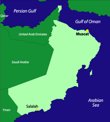
    The many forts were built during the years when Oman was an imperial power tied to Portugal and later Britain. When the British left the region, Oman pulled the covers over itself, keeping the eyes of much of the rest of the world away. But in 1970, with the ascension of Sultan Qaboos bin Said, Oman began a “makeover” period, during which modernization and a spirit of openness came to define the sultanate.

    Oman’s varied landscape includes rugged coastlines, beaches, mountains, salt flats, oases, and deserts. The sultanate has one of the world’s most ecologically friendly governments, and a wide range of wildlife thrives in many protected areas. Sanctuaries have been set aside for Arabian oryx, giant sea turtles, the Arabian tahr, Arabian wolf and leopard, striped hyena, and the sooty falcon. Protecting plant life is important to the government as well: coastal areas are preserved and there are National Protected Areas scattered around the country.

    Oman is considered a safe, secure destination, but you would not want to find yourself in the midst of demonstrations–either political or religious.

    Traveling in Oman
    Oman Air flies to many cities within Oman, and for closer travel there are intercity buses. You can also rent a car, but this is not cheap. There is also an extensive system of microbuses and taxis. Find one get in, but don’t be surprised if you don’t go anywhere right away: usually the driver will wait for a few more passagers before hitting the road. You can also hire a cab privately, but this means you are “paying” for all the seats, so expect the fare to be a lot more.

    Unless you are a citizen of the GCC (UAE, Saudi Arabia, Kuwait, Bahrain or Qatar), you need a visa to enter Oman. It is valid for one entry and cannot be extended. It’s recommended that you have an Omani travel agent or hotelier arrange your paperwork–primarily the No Objection Certificate (NOC). A road pass is necessary if you plan to travel by car. As is the case for many Middle Eastern countries, if your passport shows any evidence of travel to Israel you will be denied entry to Oman.

    What to Know
    Oman MapWhen traveling to Oman, keep in mind that you will either have to travel first class or low budget–there’s almost nothing for the midrange traveler. First-class travelers will spend a lot for better accommodation, around $100 to $150 dollars a day. Whereas the low-end traveler will likely spend $50 dollars a day on accomodations and eating. Don’t be surprised to shell out up to $200 a day on food, transportation, souvenirs, and a bed. Site seeing and other places of interest are generally free; domestic travel and eating can be relatively inexpensive, so you should decide in advance whether nicer accomodations are something you’re willing to pay for. Tipping is typically not expected–many restaurants will include an additional 10%-15% gratuity in the bill. Haggling at markets may get you a modest break in prices, but it’s not as widely appreciated as in many other countries. Traveler’s checks are easy to change, and ATMs are available most places, though they’re often not linked to international systems.

    Weather in Oman

    The best time to visit Oman is between October and March–the temperate months when the weather is the best. June to September is the monsoon season, so it’s best to avoid visiting during these times.

    Oman Information
    Middle Easy Map Population: 2.5 million
    Government: Sultanate
    Square Miles: 82,000 sq mi (212,500 sq km)
    Capitol: Muscat (population 380,000)
    Official Language: Arabic (official), English, Farsi, Baluchi, Urdu
    People: Arab, Asian, African, Baluchi
    Religion: Ibadi Muslim (75%), Sunni Muslim, Shiite Muslim, Hindu
    Major products/industries: Oil, natural gas, agriculture, fishing

  • Ireland

    Irish FlagIreland is more than just the land of Guinness and Shamrocks, it is a land of mythic beauty that is hard to forget. From the ancient Celts to the early European Christians, Vikings, and finally the Normans, Ireland has seen more history than many other places on earth. But the country has emerged from tumultuous past into the modern world as a leader in technology and economic development. The Irish have come a long way over the past few generations, but don’t let the new modern ways fool you–you can still expect to find that good old Irish hospitality all over the country.

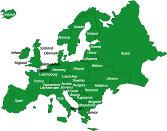
    Ireland MapWhile the Republic of Ireland gained its full independence in 1949, the long struggle against England is still alive, as seen daily in Northern Ireland. But despite what happens in the north, the Irish have never lost their spirit. When you travel around the countryside you will quickly learn why so many people believe this is a purely magical place.

    From the juxtaposition of the ultra-chic with poignant history in Dublin, to the ancient limestone-armored hillsides at The Burren, to the dramatic soaring coastlines and solemn quietude of the western isles, Ireland bears many faces. And every  one of them is fascinating and fun.

    Traveling in Ireland
    There are many ways to get to Ireland, depending on where you originate. Major airports are located in Dublin; Shannon; and in Northern Ireland, in Belfast. A number of major cities around the world have flights direct to these cities, and there’s plethora of options if flying through England. Also, ferry service runs between England; Scotland; Wales; and even Cherbourg and Le Havre, France, to various cities in Ireland.

    Most sights in Ireland are not accessible by public transportation, which means that the only way to truly see all of the countryside is by car; however, renting a car can be very expensive, and if you do plan on driving in Ireland remember to stay on the left. There are trains and buses that can get you around the country, but they do not travel to all places and their schedules can vary. If you do plan on traveling around Ireland extensively, it’s best to have a good plan before you head out–getting from hear to there is typically not as easy as on continental Europe.

    Weather in Ireland
    The weather is best in July and August, when it’s warm and the days are long. This is also the most crowded time to visit Ireland. In the winter, weather can be miserable, and the days maddeningly short. This, combined with the fact that a lot of tourist facilities are closed, makes traveling to Ireland in the winter hard on many tourists. If you’re looking for fair weather and smaller crowds, it may be wise to go there in June or September.

    Ireland Information
    Europe Map Population: 3.9 million
    Government: Democracy
    Square Miles: 43,575 sq mi (70,282 sq km)
    Capitol: Dublin (pop. 1.5 million)
    Official Language: English, Irish (around 83,000 native speakers)
    People: Irish
    Religion: 95% Roman Catholic, 3.4% Protestant in the Republic; 60% Protestant, 40% Roman Catholic in the Northern Ireland
    Major products/industries: Computer software, information technology, food products, brewing, textiles, clothing, pharmaceuticals, tourism

  • Falkland Islands

    Falkland Islands FlagBest known for the war that was fought in 1982 between Argentina and the British, this colony of Britain is still a lonely outpost of only about 4000 inhabitants, mainly consisting of British military personnel. The residents of the Falkland Islands are typically decended from the British, and culture there–while unique in many ways–is, itself, British through and through.

    The Falkland Islands were uninhabited until the late 17th century, when the Europeans stumbled upon them during an exploration of the southern Atlantic. In 1690 a British expedition landed at the Falklands and claimed them for the crown. They named the sound between the two main islands after British naval officer, Viscount Falkland; later the name was applied to the entire island group.

    Falkland Islands Map The first official settlement came in the mid-1700s, when the French set up camp, but they soon turned over their claim to Spain. Since that time, the Falklands have seen a great deal of territorial conflict–first between Spain and Britain, and then between Britain and Argentina. In 1833 the United Kingdom established a military garrison on the Falklands, effectively snubbing the Spanish claim to ownership, and in April of 1982, Argentina invaded the islands, sparking brutal violence between Britain and Argentina that ended in British victory just a few months later.

    Initially sustained by agriculture (mostly sheep farming), fishing currently accounts for the largest contribution to the Falkland Islands’ economy–including the sale of fishing licenses to foreign trawlers and exporting vast quantities of squid. Other contributing industries include export of wool to the U.K., coin and stamp production, offshore oil exploration, and limited dairy production and crops to sustain the islands’ population through the winters. The Falklands are self-sufficiant except for the military, which is provided by the British and, itself, makes a large contribution to the local economy.

    Traveling in Falkland Islands
    The only way to get to the Falklands is by air. There are biweekly civilian flights from RAF Brize Norton in Oxfordshire, England. You can also fly there from Santiago or Punta Arenas in Chile. Visa requirements are typically the same as those for entering the U.K. Citizens of the U.S., Canada, Australia, and New Zealand are generally allowed to stay six months without a visa.

    Once in the Falklands there are really only two ways to travel around to the different parts. The first is on the Falkland Islands Government Air Service (FIGAS), which flies on demand to grass airstrips throughout the islands. There are also boats for day trips that can be chartered throughout the Falklands. You could also rent a car, but remember to drive on the left.

    Tourism continues to increase in the Falklands, with an estimated 30,000 visitors in 2001. Since the local population is tiny, and festivals on the Falklands are of a different breed than elsewhere in the world (the most spectacular of which are the annual “sports meetings” held throughout the summertime, which include horse racing, bull riding, and sheepdog trials), people traveling to these islands usually do so to check out the wildlife. Though they are also the wettest months in the region, December through January tends to be the best time to view the islands’ migratory birds and marine mammals. For anglers, sea trout season runs from September through April. The islands’ “high season” last from October until April–although, that doesn’t say very much, considering the dearth of tourists.

    Weather in Falkland Islands
    October through March is the rainy season with the wettest months being December and January. However, it rains fairly steadily throughout the year, so be prepared. Between May and September is the Southern Hemispheric winter, and not a good time to visit the Falklands.

    Falkland Islands Information:
    Population:
    2805 permanent residents, plus 2000 British military personnel
    Government:
    Colony of the United Kingdom
    Square Miles:
    4700 sq mi (12,170 sq km)
    Capitol:
    Stanley (pop 1750)
    Official Language:
    English
    People:
    British
    Religion:
    Anglican, primarily
    Major products/industries:
    Fishing, wool processing, offshore oil exploration

  • Senegal

    Senegal FlagSenegal is a favorite destination among tourists to Western Africa. With its eventful history, serene plains and farmland, luxurious seaside resorts, and bustling capital Dakar, Senegal stands out among its neighbors and peers as very much a “go to” spot.

    Dakar is a modern spacious city with an intimate feel, hopping cafes, and friendly atmosphere. It’s a city of more than a million residents and yet feels very open and easy to maneuver (and to escape, if you so choose). Check out the the beautiful gardens of the Palais Présidentiel, or the bustling markets Marché Kermel and Marché Sandaga, both full of fruits and vegetables, crafts and a variety of local fabrics.

    Cap Skiring is home to some of Africa’s finest beaches and best resorts. It’s also home to much of Senegal’s large and growing ex-pat population and Western tourists. It may be more like Monaco than traditional West Africa, but if you’re craving a break and want a little taste of luxury, this may be the place for you.

    Ile de Gorée is notable for a number of reasons; including its good beaches; friendly atmosphere; and small, laid-back community. But the most important aspect of this island isn’t what happens in the present, it’s what happened in the past. Ile de Gorée was one of the last stops for African slaves before being shipped to a life sentence in the United States. It’s worth a visit.

    Traveler’s warning: The Casamance region, Senegal’s southern farmland, has a large number of rebel groups and bandits, making it a potentially unsafe place to travel if you’re not prepared. Do your research, find out what specific areas are most affected when you’re there, and use common sense.

    Traveling in Senegal
    Senegal MapTraveling to and within Senegal can be done readily by air. There are a number of airlines to choose from, including Bamako, Banjul, Abidjan, and Bissau. For the cheapest flights and most efficient planning, use a travel agent, and be sure your exit fee is included in your ticket.

    Road links to Senegal include Trans-Gambia Highway, though, in some cases, you may find the ferry service between Dakar, and Banjul and Ziguinchor to be faster, more comfortable, and safer–if more expensive–than the bush taxis. Within the country, buses are available, as are minibuses (though, it’s worth mentioning the cars rapides are actually slow and dilapidated minibuses that are best avoided). Hire a taxi to take you where you need to go; renting a car is expensive and trying–that is, not advised.

    Due to poor road conditions, the best overland route to Mali is by the Mistral International train, which departs Dakar once weekly and has good first-class seating and a dining car. One important tip: you’ll need to show your passport at each border crossing; it may be taken on the train by an inspector, but you must retrieve it yourself at the office. When your passport is taken, find out where you can pick it up… They will not remind you, so it’s on your shoulders to keep track of this essential item.

    Weather in Senegal
    Travel to Senegal between November and February, when when the air is cool and dry. But be wary of the harmattan winds coming off the Sahara, which can add some discomfort. For water-based activities, such as diving, February to April are the best months. The best bird watching can be done from November to April.

    Republic of Senegal
    Africa Map Population: 10.3 million
    Government: Republic under multiparty democratic rule
    Square Miles: 75,750 sq mi (196,190 sq km)
    Capitol: Dakar (pop 2 million)
    Official Language: French (official), Wolof, Pulaar, Diola, Mandingo
    People: Wolof (36%), Fula (17%), Sérèr (17%), Toucouleur (9%), Diola (9%), Mandinka (9%), European and Lebanese (1%)
    Religion: 96% Islam, 6% indigenous beliefs, 2% Christian
    Major products/industries: agricultural and fish processing, phosphate mining, petroleum refining, construction materials

  • Switzerland

    Swiss FlagSwitzerland, sometimes referred to as the “island inside Europe,” is a land with many identies. From its busy banking centers in the cities to the lovely mountains and Alpine villages, Switzerland is also a land of many contrasts. The robust culture of this country is exemplified by the four different languages spoken by its population: German, French, Italian, and the native Romansch.
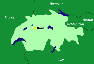
    One of the most noteable Swiss traits is their model efficiency, seen everywhere from their clean and timely rail system to their beatifully organized parks. Switzerland is a wonderful place to travel, and this efficiency makes traveling around the country so easy that day trips into the mountains or heading off to another city on a whim are easy and well worth the effort.

    Traveling in Switzerland
    Swiss Map Switzerland is by far one of the most pleasant countries in Europe to get around. The train system is first rate–clean, friendly, and efficient. Most places in the country can be reached within a couple of hours, and the train is certainly the desired mode of transport, being both comfortable and offering you the ablity to take in the scenery unfolding outside your cabin window.

    Due to what some of the Swiss refer to as their country’s “secret banking” Switzerland does not use the Euro as its currency. This is only a minor inconvience, and some places do except the Euro, as well as the Swiss Franc. Prices in Switzerland tend to be higher than other places in Europe (particularly in the summertime), but for the budget-conscious traveler Switzerland has some of the best hostels in Europe, which–for a backpacker–is the preferred place to rest your blissed-out head and tired feet. Try to book in advance as the hostels fill up quickly. In the summer, they’re often fully booked months ahead of time.

    Weather in Switzerland
    Switzerland The weather in Switzerland can vary a tremendously. Due to its rugged geography, Switzerland has many microclimates; you can leave one beautiful sunny place only to travel a half-hour away and find it cloudy, cold, and overcast. The southern part of the country gets more of the Mediterranean climate, while the rest of Switzerland tends toward conditions more typical of central Europe, with temperatures in the summer reaching 20° to 25°C, and 1° to 5°C in the winter.

    What to Know
    SwitzerlandTaking advantage of Switzerland’s great transportation system is easy. Don’t be afraid to use it to discover as much of the country as possible, which is not hard even if you intend keep a single “home base” from which to travel outward. Hostels are cheap and a good place to meet people; many have private rooms, so are more like higher-end hotels. Take advantage of travelers’ knowledge at any hostel and you’ll be able to glean more timely and pertinent information about the country–such as, other places to stay, where the crowds are, the best routes to take, good eats, etc.–than most guidebooks will be able to offer. If you intend to walk into a hostel and book a room for the same day, make sure to get there early, as many have daily sign ups for rooms that are not opened up until later in the afternoon/evening: the earlier you get your name on the list, the better chance you have of getting a bed for the night.

    Switzerland Information
    Population: 7.3 million
    Government: Federal Republic
    Square Miles: 16,105 sq mi (41,295 sq km)
    Capitol: Bern (pop 130,000)
    Official Language: German, French, Italian, and Romansch
    People: 74% German, 20% French, 4% Italian, 1% Romansch
    Religion: 49% Roman Catholic, 48% Protest
    Major products/industries: Banking, insurance, pharmaceuticals, chemicals, precision instruments, tourism