Martha’s Vineyard (adjoining the smaller Chappaquiddick Island) is an island off the United States east coast, to the south of Cape Cod, both forming a part of the Outer Lands region. It is often called just “the Vineyard”. With a land area of 87.48 square miles (231.75 km²), Martha’s Vineyard is the 57th largest island in the United States.
The Alsek River is a wilderness river flowing from the Yukon into Northern British Columbia and into Alaska. The surrounding area from the Western edge of the Alsek to East of the East Alsek is known to locals as Dry Bay.
End of the rainbow coming through the clouds
Making camp before the helicopter portage day
Telescope set up in hopes of viewing Mt. Fairweather
Mts. Hubbard, Kennedy, and Alverstone, at sunrise (3:30 A.M.)
Crowded harbor at Haines, Alaska
Icebergs on a foggy Alsek Lake (Alsek Glacier entering in the background)
Windy sand dunes off the river
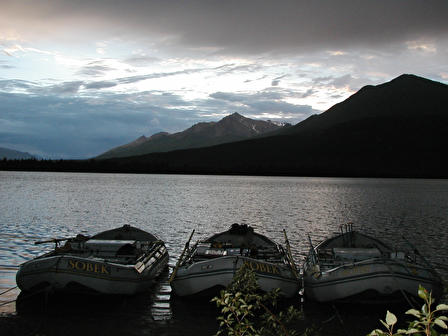
Mountain Travel Sobek inflatables on the banks of the Alsek
Wolf tracks in the sand
At the waterfront, sunset (11:30 P.M.)
Camp and icebergs on Alsek Lake–tent in foreground is a homemade sauna.
Grenada (pronounced /grɪˈneɪdə/) is an island nation that includes the southern Grenadines in the southeastern Caribbean Sea. Grenada is located north of Trinidad and Tobago and Venezuela, and south of Saint Vincent and the Grenadines. The national bird of Grenada is the critically endangered Grenada Dove.
St. George’s, Grenada
Looking at Petite Martinique from PSV
Palms St. David’s Bay
Anchorage at St. David’s Bay
Road around St. David’s Bay
The Rock at the entrance to St. David’s Bay looking east
The Rock at the entrance to St. David’s Bay looking east
Saint Vincent is a volcanic island in the Caribbean, the largest island of the chain called Saint Vincent and the Grenadines. It is located in the Caribbean Sea, between Saint Lucia and Grenada. It is composed of partially submerged volcanic mountains. La Soufrière is still an active volcano .
The territory was disputed between France and the United Kingdom in the 18th century, before being ceded to the British in 1783. It gained independence on October 27, 1979. Approximately 120,000 people live on the island. Kingstown (population 19,300) is the chief town. The rest of the population resides in the other five main towns of Layou, Barrouallie, Chateaubelair, Georgetown, and Calliaqua.
Natural Arch guarding Wallilabou Bay
Skiff in Wallibou Bay
Natural Arch guarding Wallilabou Bay
Fishing Boat Wallilabou Bay
Fishing skiffs Chateaubelair, St. Vincent
Headed toward St. Lucia
Rainclouds coming over the tall mountains of St. Vincent
Cloud cover off the north shore of St. Vincent
Sun breaking thru the clouds in shore of St. Vincent
Sun breaking thru the clouds in shore of St. Vincent
Anchorage near Richmond Point, Chateaubelair
Heading toward the cut between Chataubelair Island and St. Vincent
Heading toward the cut between Chataubelair Island and St. Vincent
Heading toward the cut between Chataubelair Island and St. Vincent
Looking out from Wallilabou Anchorage
Wallilabou Anchorage Hotel and Restuarant
Boat Boys in Wallilabou Bay
Rainclouds coming over the tall mountains of St. Vincent
Saint Lucia (pronounced /ËŒseɪnt ˈluËʃɪə/) is an island nation in the eastern Caribbean Sea on the boundary with the Atlantic Ocean. Part of the Lesser Antilles, it is located north of the islands of Saint Vincent and the Grenadines, northwest of Barbados and south of Martinique. It is also known as the “Helen of the West Indies” because it switched between British and French control so often it was likened to the mythical Helen of Troy.
Saint Lucia is one of the Windward Islands, named for Saint Lucy of Syracuse. It was first visited by Europeans in about the year 1500 and first colonized successfully by France who signed a treaty with the native Carib peoples in 1660. Great Britain took control of the island from 1663 to 1667 then went to war with France over it fourteen times, and finally took complete control in 1814. Representative government came about in 1924 (with universal adult suffrage from 1953) and from 1958 to 1962 the island was a member of the Federation of the West Indies. Finally, on February 22, 1979, Saint Lucia became an independent state of the Commonwealth of Nations. The island nation celebrates this every year with a public holiday.
Rhodes is an island in Greece, located in the eastern Aegean Sea. It is the largest of the Dodecanese islands in terms of both land area and population, with a population of 115,490 (2011 census),[1] and also the island group’s historical capital.
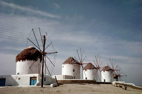
Mykonos is a Greek island, part of the Cyclades, lying between Tinos, Syros, Paros and Naxos. The island spans an area of 85.5 square kilometres (33.0 sq mi) and rises to an elevation of 341 metres (1,119 feet) at its highest point. There are 10,134 inhabitants (2011 census) most of whom live in the largest town, Mykonos, which lies on the west coast. The town is also known as Chora (i.e. the Town in Greek, following the common practice in Greece when the name of the island itself is the same as the name of the principal town).
Yalta is a resort city on the north coast of the Black Sea in the Crimean peninsula, a territory recognized by a majority of countries as part of Ukraine as the Autonomous Republic of Crimea but administered by Russia as the Republic of Crimea. It serves as the administrative center of Yalta municipality, one of the regions Crimea is divided into. These pictures were taken in October 2000.
Swallow’s Nest is a decorative castle located at Gaspra
Swallow’s Nest is a decorative castle located at Gaspra
Swallow’s Nest is a decorative castle located at Gaspra
Yalta
Livadia Palace was a summer retreat of the last Russian tsar, Nicholas II, and his family in Livadiya, Crimea. The Yalta Conference was held there in 1945, when the palace housed the apartments of Franklin Delano Roosevelt and other members of the American delegation. Today the palace houses a museum, but it is sometimes used for international summits.
Livadia Palace was a summer retreat of the last Russian tsar, Nicholas II, and his family in Livadiya, Crimea. The Yalta Conference was held there in 1945, when the palace housed the apartments of Franklin Delano Roosevelt and other members of the American delegation. Today the palace houses a museum, but it is sometimes used for international summits.
Livadia Palace was a summer retreat of the last Russian tsar, Nicholas II, and his family in Livadiya, Crimea. The Yalta Conference was held there in 1945, when the palace housed the apartments of Franklin Delano Roosevelt and other members of the American delegation. Today the palace houses a museum, but it is sometimes used for international summits.
Livadia Palace was a summer retreat of the last Russian tsar, Nicholas II, and his family in Livadiya, Crimea. The Yalta Conference was held there in 1945, when the palace housed the apartments of Franklin Delano Roosevelt and other members of the American delegation. Today the palace houses a museum, but it is sometimes used for international summits.
Views near Yalta
Vorontsov Palace or the Alupka Palace is an historic palace situated at the foot of the Crimean Mountains near the town of Alupka in Crimea. The Vorontsov Palace is one of the oldest and largest palaces in Crimea, and is one of the most popular tourist attractions on Crimea’s southern coast.
Vorontsov Palace or the Alupka Palace is an historic palace situated at the foot of the Crimean Mountains near the town of Alupka in Crimea. The Vorontsov Palace is one of the oldest and largest palaces in Crimea, and is one of the most popular tourist attractions on Crimea’s southern coast.
Vorontsov Palace or the Alupka Palace is an historic palace situated at the foot of the Crimean Mountains near the town of Alupka in Crimea. The Vorontsov Palace is one of the oldest and largest palaces in Crimea, and is one of the most popular tourist attractions on Crimea’s southern coast.
Livadia Palace was a summer retreat of the last Russian tsar, Nicholas II, and his family in Livadiya, Crimea. The Yalta Conference was held there in 1945, when the palace housed the apartments of Franklin Delano Roosevelt and other members of the American delegation. Today the palace houses a museum, but it is sometimes used for international summits.
Vorontsov Palace or the Alupka Palace is an historic palace situated at the foot of the Crimean Mountains near the town of Alupka in Crimea. The Vorontsov Palace is one of the oldest and largest palaces in Crimea, and is one of the most popular tourist attractions on Crimea’s southern coast.
Livadia Palace was a summer retreat of the last Russian tsar, Nicholas II, and his family in Livadiya, Crimea. The Yalta Conference was held there in 1945, when the palace housed the apartments of Franklin Delano Roosevelt and other members of the American delegation. Today the palace houses a museum, but it is sometimes used for international summits.
Livadia Palace was a summer retreat of the last Russian tsar, Nicholas II, and his family in Livadiya, Crimea. The Yalta Conference was held there in 1945, when the palace housed the apartments of Franklin Delano Roosevelt and other members of the American delegation. Today the palace houses a museum, but it is sometimes used for international summits.
Vorontsov Palace or the Alupka Palace is an historic palace situated at the foot of the Crimean Mountains near the town of Alupka in Crimea. The Vorontsov Palace is one of the oldest and largest palaces in Crimea, and is one of the most popular tourist attractions on Crimea’s southern coast.
Swallow’s Nest is a decorative castle located at Gaspra
Swallow’s Nest is a decorative castle located at Gaspra
Swallow’s Nest is a decorative castle located at Gaspra
Swallow’s Nest is a decorative castle located at Gaspra
Swallow’s Nest is a decorative castle located at Gaspra