Blog

  • Charlotte Amalie, St. Thomas; Virgin Islands

    Charlotte Amalie, St. Thomas; Virgin Islands

    Charlotte Amalie is the capital and largest city of the U.S. Virgin Islands. It is located on the island of Saint Thomas and as of 2004 had an estimated population of 19,000 (the 2000 U.S. Census found a population of 18,914).

    The city is named after Charlotte Amalie of Hesse-Kassel (or Hesse-Cassel) (1650-1714), queen consort to King Christian V of Denmark. It is famous as a deep-water harbor that was once a haven for pirates and is now a famed cruise ship port of call, with about 1.5 million cruise ship passengers landing there in 2004. Charlotte Amalie has many buildings of historical importance and is home to the second-oldest synagogue in the Western Hemisphere.

    [ad#468×60]

  • Tortola – British Virgin Islands

    Tortola – British Virgin Islands

    [mapsmarker layer=”2″]

  • Solomon Islands

    Solomon Islands
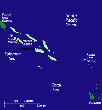
    Solomon Islands MapMillenia of immigration of Melanesians, Polynesians, Asians, Micronesians, and Westerners has made the Solomon Islands one of the most culturally rich island nations in the world. With thousands of small villages still espousing age-old beliefs and practicing ancient customs, locals are generally more than happy to allow you access to their land and entrance into their unique world, as well as help you find your way around the many small islands and vast lagoons that make the Solomons famous.

    Solomon Islands FlagTraveling to the Solomon Islands is not easy, with a troubled economic infrastructure, and fewer flights landing in its capital Honiara; however, the world-class scuba diving, fishing, snorkelling, and birding, as well as the colorful culture and the welcoming nature of the islanders makes this place very much worth a visit. Historically, interest in the Solomon Islands is focused on the role they played in the Pacific during World War II–the wreck-strewn waters of Iron Bottom Sound are testament to the strategic importance of the islands.

    Caution: Due to a rise in ethnic and economic tensions in the Solomon Islands, the U.S. and Australian governments have issued travel advisories against going to certain parts. Most visitors will attest that these tensions do not typically affect travelers; however, it may be worth investigating the region’s social and political situation before departing.

    Traveling in the Solomon Islands
    Because of their remote proximity to major regional air routes, the Solomon Islands remain quiet and unspoiled by tourism. Most of the hotels are located in the capital. Outside Honiara, facilities tend toward small hotels and basic village resorts. The Western Province offers spectacular lagoons and shallow coral reefs that are ideal for snorkeling and scuba diving.

    Inter-island transport is provided by Solomon Airline (the national airline) and Western Pacific (a privately owned local airline). During peak travel times–typically around the end of the year–it can be difficult to secure a seat without a booking several weeks in advance. Boat travel is available between all the islands, but because of the time it takes to traverse the waters between them, few visitors choose to use this method.

    Because the Solomons do not have a well-developed tourism infrastructure, it has remained comparitively pristine, both culturally and ecologically. For those willing to embrace the relative discomforts of travel in the islands, the experience is sure to be a rewarding one.

    The currency is the Solomon Islands dollar (US$1 = SI$3.5, approx.). Travelers checks can be exchanged in provincial capitals only, though it’s best to exchange traveler’s checks at a bank in Honiara before departing for other areas. Major credit cards are widely accepted in hotels and restaurants in Honiara, and at the larger hotels and resorts in the provinces. Tipping is not advised.

    Malaria risk is highest during the wet season. Mosquitoes avoid sprayed areas and come out mainly at dusk–so keep yourself sprayed, sleep under a sprayed mosquito net or in a screened room, wear long sleeves and trousers if you go out at dusk, and see your doctor before leaving for the Solomons for antimalaria medication.

    Weather in the Solomon Islands
    The climate in the Solomon Islands is tropical. Average daytime temperatures are around 85°F. Water temperatures are roughly 80-85°F. November through March tends to be hot and humid, with monsoon rains and the possibility of cyclones. April through October is drier and windy.

    Solomon Islands Information
    Population: 441,000
    Government: Parliamentary democracy
    Square Miles: 62,000 sq mi (1.35 million sq km); 10,750 sq mi (27,556 sq km) of dry land
    Capitol: Honiara
    Official Language: Solomon Islands Pijin, English and 67 official indigenous languages
    People: Melanesian (95%), Polynesian (4%), Asian and Micronesian (1%)
    Religion: Christian denominations (96%)
    Major products/industries: Timber, fish, palm oil

  • Finding the Heart of the Alsek

    Finding the Heart of the Alsek

    photographs by Jeff Walpole
    On the Alsek RiverOn every river you can find one place that’s so full of mystery, life, and beauty, that it’s like finding the very heart of the river itself. It may be a shadowy, swirling pool that reflects light in such a way, you could swear you were seeing into another world. Or it could be an easy bend where the rush has undercut the bank, and trees’ roots dip into the stream. They are images of every river, but something about that particular spot makes it seem different, unique, and inspired. On the Alsek, you can find that place after each turn.

    Alaska MapThe Alsek River is not easy to find (it’s short, often not labeled on maps or in atlases) and a challenge to get to: we traveled to Juneau, Alaska, a capitol city accessible only by air and sea, and took a ferry on the Alaska Marine Highway system up the spectacularly immense Lynn Canal fjord to the panhandle fishing town of Haines. From there, we drove five hours in a school Area of interestbus into the Yukon Territory, Canada, to the Kluane National Park and Reserve town of Haines Junction; then we hiked in several hours to the banks of the Dezadeash River–near the confluence of the Kaskawulsh River–just upstream from where the Alsek begins in earnest. Here, we joined our guides, acquainted ourselves with the two-ton (loaded) inflatable oars rafts that would be our primary mode of transportation for most of the next two weeks, and set off downstream.

    This was the start of a wilderness so remote that once we were on the water, we wouldn’t see another group of humans for more than ten days. It’s a part of the world where there are mountains as far as the eye can see, many soaring to 10,000 feet or more, and most of them still unnamed. The same goes for the glaciers, flowing from a lake of ice in the center of the adjacent mountains that’s so vast, an entire range has been named for it (the Icefield Range), its frozen rivers coursing through the valleys and filling the Alsek with frigid water, icebergs, dirt and silt, boulders, and more, as they grind the earth beneath their creeping weight.

    Hiking near the AlsekOn our hike into the launching point, we saw the first of eight bears (black and grizzly; a low number, compared to some trips, but we weren’t disappointed), as well as any number of regionally specific birds, including trumpeter swan, golden eagle, and Arctic tern. We were a group of fourteen, including three highly experienced professional guides. Ours was a private trip organized by an old friend, Mike Pratt, who had run the Alsek more than any man before him; he would be our lead guide on the river, and this would be his last commercial trip down it, before settling into married life in his home back in the contiguous United States. The gear, itinerary, and all three guides had signed on through the international adventure travel company Mountain Travel Sobek.

    Running the Alsek is not for the faint of heart. We were twelve days on the river, hiking and paddling and very often fighting off the dampness of 34º water; sometimes enduring a bone-chilling rain that turned to snow just up the side of the nearby mountains; sleeping in tents filled with mosquitoes “big enough to carry off grizzly bear,” I heard someone joke; not showering or bathing properly; sharing ourselves and our most intimate moments with a group of people. But it’s not bad either. There are special things on the Alsek: a herd of mountain goats that graze on the grassy slopes of a hillside named specifically for them (Goatherd Mountain); the soft fluorescence of blue ice at the core of a massive, recently calved iceberg; and of course, the ancient whispering rush of currents at the confluence of two great rivers: the Alsek and its more frequented neighbor, the Tatshenshini.

    In the first few days we got our bearings. We tried our hands at the oars (though our main jobs would be to paddle when the oarsman/guides needed our help, or when we needed the circulation to keep warm). We acclimated to the temperature, altitude, and environment. We got to know our tents and, in some cases, our tent mates. And we asked questions–lots of questions… Will we see many bears? What do we do if we see one up close? [Counter to many people’s understanding, our guides refer to the popular “bear bell” as a “dinner bell,” because it is more likely to attract a bear, than deter it.] How well will we eat? How often will we eat? Where will we do our “business”? What are the rapids like? What happens if we fall in the cold, cold water? How far can we roam without a companion, bear spray, knife, guide, or otherwise? Questions. Questions. Questions. Listening to us, you might think we’d never set foot outside our urban enclaves before, protected by the convenience of a McDonald’s on every corner and a Starbucks in between. In fact, for the most part, all of us had reasonable experience in the outdoors: camping, trekking, rafting–roughing it, as they say. But none except our guides had ever been to a wilderness so removed and dramatic as this. It had an immediate effect: it turned us into excited little kids, with a new question for every answer we were given.

    What? How? When? Where? Why? It sounds rather pesky, but on the Alsek, where danger can arise at every turn, these questions must be asked. What do you do when you’re standing face to face with a grizzly? You gently raise your arms to the sky to show that you’re not threatening, then you speak quietly to the bear, while slowly backing away in an oblique direction: “Hey bear,” you might say, “Ho bear. I don’t mean any harm. Just passing through…” And if the grizzly decides to charge, and you’re lucky enough to have bear spray at hand, then you make sure–in the split second you have to think–that you’re not downwind, when you spray that animal right between the eyes. One small can of bear spray (essentially, mace for a 1,200 pound beast–guns are strictly forbidden in the Canadian parks system) will almost always disable the animal, sending it into the woods to tend to its stinging senses. If you’re downwind and the spray blows back on you, you’ll feel the very unfortunate effects yourself. Of course, if you’re unlucky enough to be without the spray, you should drop to the ground, face down, cover the back of your neck, and let the bear maul you. Very often he or she will simply play with you before losing interest, but “playing” with an animal six times your size, with gnashing teeth and razor sharp claws means being thrashed and slashed open, severely injured, or even killed. And that’s the point: there are many opportunities to lose your life on the Alsek, if you’re not careful. That’s part of what makes it such a wilderness adventure.

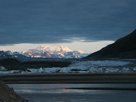
    A view of Lowell Glacier from the top of Goatherd MountainBut danger is only one side of the equation. Depending on your method of travel–using a professional company, with guides who are also great cooks, storytellers, naturalists, and jokesters; or a self-guided trip down the river, which can be not only more dangerous (for not having at least an idea of what to expect), but also less inspiring, if you’re not totally familiar with the Alsek–for every threatening moment, there can be ten more that are comforting and even luxurious. On our third day, camping at a site we called “Sandblaster” because of its uncomfortably strong winds and barren sandy landscape that pelted us horizontally in the gusts, we were treated to an exhilarating hike up Goatherd Mountain, from the top of which we had the best vantage possible of the enormous Lowell Glacier–a frozen river of mud and ice so wide it resembles a 50-lane superhighway; then we feasted at the river’s edge on a delicious dinner of fresh grilled sockeye salmon and vegetables, with tea and hot chocolate; followed by a site I thought I’d never see in such wilderness: a makeshift–but ingeniously engineered–sauna, made from a spare tent covered with heat-trapping tarps, the steam created by dripping glacier water over three heavy steel bricks that had been buried in the fire pit for hours. Later, our night was defined by the blowing wind and the rhythmic rumble of icebergs calving into the river, and well before the rest of camp rallied, a few of us woke for a glorious view of the 3:30 A.M. sunrise over the ever-present Mounts Kennedy, Alverstone, and Hubbard, which themselves seemed to rise out of the much closer Lowell Glacier. It is the kind of picture, I think, mere words cannot describe adequately. Even a photograph seems only to partially capture the environment of the Alsek. In the end, I knew, I was witnessing among the best the earth had to offer; after this trip, I thought, I would not sense the world around me in the same ordinary terms I once had.

    This was indicative of our experience there: work hard in the day–paddling and hiking through a spectacular environment, while finding harmony with cold rain and winds, icy river water, and sometimes frozen air–and unwind at night with a hot meal, good drinks, stories, games, and a warm sleeping bag. When we were lucky enough to find a camp with a long, flat beach, we’d set up a horseshoes pit, or play a sort of tug-of-war game called “hunker down,” which involves two opponents balancing opposite each other on ammo cans (used on river trips for easily accessible airtight containers) and trying to force each other to fall to the ground by strategically pulling and releasing the end of a rope that the players hold between them.

    A sunrise on the AlsekThere are several places on the Alsek where I thought the world had invented itself in the most striking and beautiful possible form. The purple sunrise on Mt. Hubbard, behind the meandering Lowell Glacier; the fresh fallen snow on a jagged nameless peak that reminded me of something from a Tolkien novel; the churning holes in the great rapid Lava North, for which we donned dry suits and an extra measure of courage to run (falling in the river there can mean certain death, if you get caught in an eddy); or the eerie silence on a foggy morning as we gathered firewood on a sandbar at the head of Alsek Lake. But despite all of these amazing natural wonders, the time my adrenaline hit its peak was not while immersed in the unadulterated landscape of the Alsek, but rather, while hurtling through the air, hundreds of feet above the seven-mile-long face of the Tweedsmuir Glacier, staring down at the boiling cauldron of rapids in the impassable Turnback Canyon, from the relative safety of a speeding helicopter. This was our portage day.

    Turnback Canyon is a place on the Alsek–a river known more for its pristine beauty, than its dangerous rapids–where the valley walls contract from roughly 1.5 miles wide to about 30 feet over a very short span. The boils, holes, eddies, and falls created by that dramatic change in the river’s dimensions, makes it virtually impossible to pass through and survive. In 1971, the legendary kayaker Walt Blackadar became the first to run Turnback. It was by shear luck–he said later on–that he lived to talk about it. Only having successfully paddled through the treacherous canyon did he claim it was unrunnable and he would never think of doing it again. Afterward he said, if he could have turned and gone back after the very first rapid, he absolutely would have–a humbling admission from a man who had seen, perhaps, more whitewater adventure than any other by the time he died kayaking seven years later. Since then only a handful of boats–inflatables like ours, as well as kayaks–have tried to make it through Turnback Canyon, and just a few of them have emerged safely on the other end. Thus, we arranged for a helicopter to meet us at the last camp before the canyon, to haul us and our gear over it. The cowboy pilot at the helm was like someone out of the movies, telling us one moment that he wasn’t allowed to dive into the canyon, and the next, doing just that at a speed so jarring and exciting that I simultaneously wanted to lose my lunch and get my pilot’s license. Once on the other side, we reassembled our gear and began the leg of our journey that traversed the lower end of the Alsek, heading toward Alsek Lake, and beyond that, the ocean.

    Helicopter portage of Turnback CanyonAlsek Lake was the site of our final night. But more than that, it was a culmination for me: so full of grace and beauty, awesome size and geology, wildlife, quietude, color, and light that I thought, if the entire two weeks were spent there alone, the trip would still have been amazing. The entrance into the lake began at the tail end of one of the most arduous rains we experienced. After paddling through the morning, we stopped at a beach at the head of Alsek Lake. A short walk through fields of wildflowers–blazing Indian paintbrush, fireweed, goldenrod, and more–opened up to the iceberg-laden water, still hidden in afternoon fog. Through that mist, we’d find our last camp.

    As we paddled across the lake, we slowly entered what might have been a completely different universe from the rain and cold of just minutes before. The clouds broke and the blue sky opened over us, light beaming onto the house-sized blocks of ice floating before us. I looked around and saw, between narrow spits of land in the distance, the vast plains of three tremendous glaciers. They were the Alsek Glacier–spilling into the lake, its towering face calving huge chunks of ice; the Grand Plateau Glacier; and the sprawling Novatak Glacier. And even farther away, almost painted on the background, Mt. Fairweather rose high into the sky. At roughly 15,300 feet, Fairweather is the region’s highest peak, and it is situated practically right next to the ocean. The name comes with a touch of irony as it can generally only be seen when the weather is clear, which is not often in those parts, but we were the lucky ones.

    Alsek LakeAs we tied our boats together–creating a single, wide float–and paddled among the ice, with blue evening sky overhead and a rainbow of colors reflecting off the surrounding water, I spotted the flash of a great bald eagle sweeping down the valley wall. Graceful, fast, and furious with its talons flared, the eagle slammed into the placid lake and almost immediately began to struggle under the weight of the salmon in its claws as it took flight again. It was an image I had only dreamed of up to that point. And as that dream slipped into reality, I thought, that–for me–was the true heart of the Alsek.

  • Panama

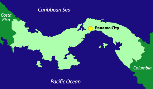
    Panama MapPanama has a checkered past, but as a modern country it runs one of the world’s most important waterways, the Panama Canal, and has built for itself a large offshore investing business. From its capitol at Panama City to its rainforests and rich coastlines, Panama is a beautiful land, but it suffers from increasing crime and an uncertain government.

    Panama is a proud and striking nation with a population of seven indigenous groups and a strong Spanish legacy. And it’s is a wonderful place to travel, as long as you’re careful and conscious of your surroundings.

    If you want to see Panama at its cultural best, Carnaval is celebrated the weekend before Ash Wednesday in Panama City. It’s one of the largest and most vibrant Carnaval celebrations in the world.

    Traveling in Panama
    If you are an American, Japanese, New Zealander, or Venezuelan citizen, it is required that you have a tourist visa or tourist card to enter Panama. You should contact your embassy or consulate for details.

    While traveling in Panama is considerably cheaper than traveling in the United States, for instance, it will also tend to be pricier than most other Central American countries. Expect to pay about US$20-30 per day, on a moderate budget, for Panama Mapfood, accommodations, and other expenses. A budget traveler can find room and board for as low as US$10-15 per day. The Panamanian currency is called the balboa, but it’s exactly the same as the U.S. dollar, from the rate of exchange (which is unnecessary if using U.S. currency) all the way to the bills they use. Even the coins are the same shape, weight, and substance as U.S. coins. Exchanging other types of currency can be easily done at a casa de cambio, of which there are many throughout the small nation.

    Tipping 10% of your bill can be done at finer restaurants; however, it’s not necessary at more casual establishments, such as cafes. Haggling over goods is not customary in Panama.

    Health Risks in Panama
    Health risks include dengue, hantavirus, malaria, rabies, and yellow fever. It is advised that you consult a doctor about what shots you may need before traveling to Panama.

    Weather in Panama
    The best time to go to Panama is during the dry season, between December and April. During the rainy season the weather can be humid, damp, and very uncomfortable, especially if you take part in strenuous activities like hiking, etc. The rain in Panama typically comes in short downpours that have a cooling and cleansing effect on the air.

    Panama Information
    Population: 2,800,000
    Government: Constitutional Republic
    Square Miles: 30,420 sq mi (78,000 sq km)
    Capitol: Panama City (pop: 700,000)
    Official Languages: Spanish, English, and Native languages
    People: 65% mestizo, 14% African descent, 10% Spanish descent, 10% Indian
    Religion: 85% Roman Catholic, 10% Protestant, 5% Islamic
    Major products/industries: Banking, construction, petroleum refining, brewing, cement and other construction materials, sugar milling, shipping, and agriculture

  • Carlsbad Caverns, New Mexico

    Carlsbad Caverns, New Mexico

    As you pass through the Chihuahuan Desert and Guadalupe Mountains of southeastern New Mexico and west Texas—filled with prickly pear, chollas, sotols and agaves—you might never guess there are more than 300 known caves beneath the surface. The park contains 113 of these caves, formed when sulfuric acid dissolved the surrounding limestone, creating some of the largest caves in North America.

    [mapsmarker marker=”4″]

    [ad#468×60]

  • A Weight Off Your Shoulders

    Big vs SmallBackpacking has gotten more and more popular as a form of traveling, and for obvious reasons: for people going to multiple destinations, carrying gear on your back helps keep you mobile while having everything you need at arm’s length. But as more “nomadic” travelers are heading out in the world, the packs they carry seem to get bigger and bigger. It’s not uncommon, these days, to see people carrying backpacks that look more like skyscrapers towering over their heads, or backpackers looking as though they might collapse under the weight of their bag. Traveling light is one of the greatest advantages of backpacking, and packing wisely can help make your trip much more enjoyable.Over the last 10 years I have traveled throughout Europe, the Caribbean, and elsewhere, never taking more than a 2500-cubic-inch backpack with me. This small size can be tough if you’re going out for an extended period (more than a few weeks) or are traveling to both hot and cold climates. But even if that’s the case, you shouldn’t need a bulky 5000-cubic-inch pack or more, which–fully loaded–makes falling over easier than standing up.

    Simply finding a place to store your pack for the day is much easier when you’re not toting all that weight. Ever try fitting a big internal-frame pack into a locker at a train station? It’s nearly impossible. And walking around a city for a day while shouldering that burden is not fun.

    Below is a list of items that can fit easily into a small pack, with room to spare. Of course, the things on this list will vary depending on your destination, bur the idea remains true. Use this as a starting point.

    HeadlampClothes:
    7 pairs of underwear (or 1 pair for each day, if the trip is under 2 weeks; max 14 pairs)
    7 pairs of socks (or 1 pair for each day, if the trip is under 2 weeks; max 14 pairs)
    5 to 6 T-shirts
    2 to 3 collared or over shirts, to wear on top of your T-shirts
    1 pair of shorts (2 if you are going to a warmer destination)
    1 to 2 pairs of long pants–one being jeans; the other, khakis or similar (or wool if your are going to a colder destination)

    Shower KitFootwear and Jackets:
    1 pair of comfortable shoes (leather hiking boots are best as they can often be used as dress shoes, if going to a nice restaurant, etc., instead of wearing your tattered tennis shoes)
    1 pair of water-proof (river) sandals (if going to a warmer destination; also good to wear if you plan on staying in hostels and/or using public showers)
    1 warm jacket (if going to colder destination)

    Extra Stuff:
    1 umbrella (collapsible, make it as small as possible)
    Water Bottle 1 quick-dry camping towel (medium size)
    1 headlamp or flashlight (headlamps might make you look dorky, but their advantages outweigh all else)
    1 camera (digital, if you have it, with an extra memory card)
    1 paper-back book (not including guidebooks; to keep you busy during those long train rides)
    1 paper-back journal
    1 pen
    Moneybelt 1 money belt (or a money/passport case that you can wear under your clothes)
    1 water bottle
    1 shower kit (that can be easily hung up)
    1 set of playing cards
    Pass the Pigs 1 travel game (“Pass the Pigs” is a favorite of mine)
    1 small luggage lock (to secure your backpack zipper)
    2 medium bungy cords
    2 key-chain carabiners
    1 day pack/book bag (something you can bundle into a small size when not in use)

    All of this and more will fit nicely in a 2500-cubic-inch backpack. And if your pack is a little bigger you’ll have plenty of extra space for whatever else you might want to take. But anything over 3500 cubic inches is most likely overkill–you probably won’t end up needing that much room. Bringing a lot of extra clothes is an easy trap to fall into, but most places will give you the option of cleaning a shirt or two (in the sink, shower, or wherever) and hanging them to dry in a pinch. That said, it’s a good idea to bring a small plastic container of biodegradable liquid laundry detergent.

    Don’t leave home with your backpack stuffed to capacity, as that will probably be your best packing job throughout the whole trip. Somehow, repacking properly gets harder and harder as you go, so if you have a small backpack that is stuffed to the gills, then you should certainly upgrade to one a just little bigger.

    Using bungy cords to strap extra footwear or wet clothes to the outside makes drying and packing a lot easier. (Carabiners can be used for the same purpose.) Chances are, most people will not want to steal your smelly shoes, and bungy cords are important for keeping loose items from flopping around and becoming a nuisance.

    Packed and Ready to GoIt’s understandable that many people would want to bring more gear than what I’ve suggested–after all, you can never be sure of everything you might need along the way–so if you plan on going for an extended period (several months), taking that big pack seems sensible. Who wants to wear the same clothes for 6 months, after all? But as with everything, you should be prepared to make certain sacrifices. Getting rid of some of the more extraneous gear will make touring a lot easier on your shoulders and back, which in turn, will make it easier on your state of mind.

    Remember most big packs (4000 cubic inches or more) were designed for long-term expeditions in remote areas, where you need this added space for a sleeping bag, camp stove, food, and other basic survival gear. For most backpackers, these days, surviving means little more than finding the nearest hostel and hoping it has a bar. It’s amazing how much simpler, and more enjoyable, traveling can be when you pack light and leave the kitchen sink at home.

  • Trailing the Fall of France

    by John Stinson
    Area of interest As a student of World War II, I have been fascinated by what is one of history’s greatest battles, the breakthrough that led to the fall of France in May 1940. Unlike the famous one- or two-day battles such as Waterloo, Antietam, and Gettysburg, there are no monuments or museums to this singular campaign; it is an event the western world would like to forget. But the absence of memorials is, itself, indicative of one thing: this was a battle of movement. I set out to retrace the steps of the soldiers and the tracks of the tanks in this campaign.

    World War II began with the invasion of Poland on September 1, 1939. Although France and England declared war, they did nothing to help their eastern allies. After Poland fell, the “Phony War” left allied England and France, and Germany sitting quietly on their borders, with Belgium in between, hoping the Germans would leave them alone. The Maginot Line, a vast network of underground bunkers and blockhouses built between the two wars to protect France from German invaders, extended only to the southern border of Belgium, making that country all the more obvious as the invasion route. But Belgium suffered so terribly in World War I that it chose not to consider the inevitable.

    The German plan was to attack through central and northern Belgium, as expected, while quietly sending a mobile Panzer corp through the southern Ardennes Forest of Luxembourg and southern Belgium in hopes of outflanking the main British and French armies–effectively going around the Maginot Line, instead of trying to go through it. The plan worked to perfection because the French thought the hilly and heavily wooded Ardennes was an unlikely line of attack, especially for tanks. Virtually unopposed, the Germans were able to reach the crucial line of the Meuse River, cross the lightly defended barrier, and move swiftly north to cut off the allied armies. The war in France was essentially over in a week, though the fighting continued for another month.

    When Germany invaded on May 10, 1940, the allies advanced to planned positions in northern Belgium. This was exactly what Germany wanted. The news was all about the fighting to the north, but while attention was turned toward that battle line, the German Panzers led by Heinz Guderian unexpectedly arrived at Sedan on the Meuse, to the south.

    Backtracking to the opening day, the most famous event in the northern region was the taking of Fort Eben Emael at the junction of the Albert Canal and Meuse River on the Belgium-Holland border. German glider specialists landed on top of the huge fort and neutralized it before the invading army arrived. Taking the fort was more spectacular than important–perhaps an example of Hitler’s uncanny feel for psychological warfare. World War II strategy called for bypassing such obstacles, but Eben Emael is testimony that Allied thinking was still mired in the previous war. They could not have expected the inventive mode of attack, and thus the 1,200 Allied forces inside were overwhelmed by 78 German invaders. The fort is still there, a huge rectangular structure with miles of tunnels. It lies only a few miles southwest of Maastricht, and is worth a visit, less for the fort itself than for the beautiful site.

    As I traveled through the region, my attention was focused on the tank corps slipping through to the south. The Ardennes is hilly, forested, and chopped up with many streams, in other words easily defensible country. For this very reason, the French thought it was impassible for tanks. The French identified tanks with open country, overlooking that the Germans were merely using the Ardennes as an undefended highway.

    Area of Interest, German invasion routeThe tank was invented during World War I and early models were cumbersome. Early tanks had a maximum speed of roughly 5 miles per hour and crossing a stream presented difficulties because of their weight; country bridges were often unable to support them. At the opening of the Second World War, German tanks were relatively light and emphasized mobility. Many French tanks were heavier and used largely in support of infantry, perhaps leading to the confusion about difficulty of passage. The British invented the idea of unified separate tank corps supported by mobile infantry, but only the Germans put the tactics to use. They tested independent use of tank divisions in Poland, but the French took little notice, even though success in Poland dictated similar tactics in France.

    About half the Ardennes is in Luxembourg, which had only a ceremonial army. The French were informed by the local villagers and even had scouts in the area, but poor communications left Allied headquarters believing this German posturing was a minor event. The French commanders assumed it would take the German Panzers about 10 days to reach the Meuse. In fact, Guderian and his division made the trip in 3.

    I began my excursion with a diversion to Bastogne, in southern Belgium, which gained notoriety in the Battle of the Bulge, four years later. This town has the usual tourist attractions–monuments and a war museum–and modern-day Bastogne continues to identify itself more with the war, than with anything else. Leaving Bastogne, I went south to Martelange on the Luxembourg-Belgium border, which the Germans reached on the first evening of their advance. I then took the road west to Neufchateau (Neufchateau also became well known in the Battle of the Bulge). Going east out of Neufchateau in the direction of the center of the German advance, I followed a narrow road along a stream–a road probably much the same today as in 1940. Despite the enticing lush, green landscape, this is rugged wooded country, and should have been easy to defend. Nevertheless, all the Germans had to do was drive off a few Belgian troops posted at occasional crossroads. Their target, as was mine, was Sedan, on the Meuse River.

    The French state of mind is illustrated by their casual attitude toward manning a line they knew to be crucial. Part of the French mental block was the idea that rivers would stop tanks. Pontoon bridging for walking infantry, in use for centuries, requires only light equipment. The French discounted the ability of heavy trucks to carry tank-bridging equipment. Again, they had not allowed modern techniques to penetrate their World War I mentality. In particular, the French saw the Meuse River, approximately marking the western boundary of the Ardennes, as a major obstacle that would require considerable time to bridge, even though German tanks had already sprinted across larger rivers in Poland. French planning called for a minimum of 10 days to reach the Meuse based on the number of other rivers and streams that had to be crossed first.

    A shallow spot in the Semios RiverThe most important of the intervening rivers is the Semois. The Semois is a meandering river with tight, graceful curves, cutting through almost pristine forestland. This river now provides a place for many to relax on its banks, or play in its water, but at the time, it represented a major entryway into French territory. The Semois is no mere stream and at that point its bridges had been blown. However, the river is extremely shallow in many places, and a shallow ford with a firm bottom could be crossed without bridging. At other points the Semois is considerably wider and therefore even shallower. Driving along the river in the area where the tanks traversed revealed many good crossings adjacent to the road. German sport fisherman had picked out ahead of time the fords with the shallowest, sturdiest bottoms where the tanks could cross without getting bogged down in the river bed.

    After searching for passable fords in the area, I continued west to the spectacular town of Bouillon, on the Semois, a convenient stopping point. The town sits in the river valley at a sweeping curve of the river, its centuries-old buildings (including the Castle of Bouillon–once occupied by Godfry V, leader of the first Crusade on Jerusalem) creeping up the steep banks on either side. Not far from the ancient fort is the justly named Panorama Hotel, where Heinz Guderian spent the night of May 12. Its spectacular view makes a visit worthwhile.

    By the evening of May 12 (the third day) Guderian had reached the Meuse at Sedan with the main force. Sedan is only a short drive from Bouillon. Steep banks along much of the Meuse in this region means it is easily protected; Guderian headed for Sedan specifically because the countryside there is flat on both sides of the river, making a crossing more difficult to oppose.

    Steel bridge over the Muese in HouxCommanding the northernmost arm of Guderian’s Panzer corps–before he became an infamous figure in the war–Erwin Rommel’s division reached the Meuse, on the same day as Guderian, but roughly 40 miles to the north, just above Dinant. His route, unlike Guderian’s, did not go through undefended Luxembourg, and Rommel ran into more resistance. But the roads were better and Rommel, himself, was driven like no other division commander. When he reached the Meuse at Yvoir, the bridge had been blown. Rommel went up river (south) to find a crossing. Here, in an area with low river banks, he found an old weir, or low dam, between the shore and a small island at the little village of Houx. The weir extended to the western bank. Rommel promptly got troops across on top of the weir, under cover of darkness. It’s all there today, except that the old wooden dam has been replaced with steel and a foot bridge. As they reached the far side, history books describe the troopers as crouching under the bank fighting off French defenders, but in fact there are no steep sides here and the country to the west is reasonably flat. The next morning, several hundred yards upstream, Flat country near Rommel’s river crossingRommel strung a cable over the river capable of carrying pontoon-supported vehicles. After commandeering another division’s bridging equipment (his had been used farther back) a full pontoon bridge was laid a mile upstream, at Bouvinges, on May 14. Tanks were moved over the Meuse both here and at Sedan.

    Finding remnants of those historic days is difficult. No monuments stand to the German invaders. The Auberge de Bouvinges, a small hotel between Houx and Bouvinges on the western bank, known for its excellent dining room, has pictures of Rommel’s crossing on its walls, but these are the sole artifacts I found of those famous events.

    As a military historian, I was interested in why the French thought of the Meuse as a formidable barrier. Along much of its course, in this area, the banks are high and easily safeguarded, but there are low points, principally at Sedan, and it was at these that the Germans directed their attention. Sedan is in France, so the French had not been inhibited from building defenses, but the troops there were both second line and few in number. Reinforcements were slow coming up, because attention was directed to the north.

    Guderian had forced a crossing by late in the afternoon of May 13, a mere day after his arrival, before the French could react. Lack of attention to Sedan is all the more remarkable, as the city is infamous in French-German military history as the place of Napoleon III’s defeat in 1870, after which the Germans marched into Paris.Sedan is an unattractive, small city. Some of the other crossing towns, such as Dinant and Namur (the target of the Bulge counterattack in 1944) make for better stops, but no matter where you are on the Meuse, the striking geographic feature for the military historian is the river’s narrowness. At Dinant (just south of Rommel’s crossing) and Sedan, the Meuse is only 100 yards wide. Stand on the river bank just below Sedan and imagine crossing under fire in a rubber raft. Frightening, to be sure, but not impossible, especially with a rain of fire behind the paddlers and the Stuka dive bombers, their sirens screaming, causing the French defenders to protect all sides. And at such close range, tank and machine guns firing from the east bank had a strong influence. The Germans were short of artillery, but were near enough that heavy artillery was not needed. The more the German feat is analyzed, the easier it is to understand, especially given French incompetence and defeatism.

    The best account of the fall of France is Alistair Horne’s To Lose A Battle. The book sets the tone for the collapse by examining the French mentality resulting from World War I and conditions in France between the wars. Horne also wrote on the Verdun battle in World War I, in his book The Price of Glory. This induced me to drive on to Verdun, an hour and a half south of Sedan, where I found a clue to the French defeat in 1940.

    Monument outside VerdunVerdun is a medieval town steeped in military history–from the Treaty of Verdun in 843, which divided the vast empire of Charlemagne among his warring grandsons; to the bloody battle of 1916, in which an estimated 700,000 French and Germans lost their lives, so that no side clearly won; to the 1984 United Nations declaration of Verdun as an “International City of Peace.” Two principal forts defending Verdun still exist. One in particular, Douaumont, appears unconquerable as it dominates the surrounding terrain. However, not only did the Germans succeed in taking both forts, but the French retook them later (from the easier back side). The limitation of such strongholds under modern conditions would seem to have been demonstrated. Nonetheless, impressed by how long one of the forts held out, the French were encouraged to build the Maginot Line.

    The monumental ossuary outside Verdun is striking for its deep sense of doom. This is a tomb, not a glorification of victory. The windows have plaque-like overhangs that give the appearance of tears. At the back, on a slightly lower level, is a chapel. The service being conducted while I was there befitted the utter gloom of the structure. In front is a large cemetery. Unlike the uplifting American cemeteries in
    Verdun Monument
    Monument outside Verdun
    Europe, with beautiful crosses of white marble, the French crosses are made of concrete, left to crumble from lack of maintenance, casting a gray, desolate image.

    The tone of Verdun comes from the appalling casualties in the great battle there. Mutiny surfaced late in the battle, and subsequently in other segments of the French army. The French suffered so terribly in the First World War that an unwillingness to face a similar fate a mere 22 years later is not surprising. Although German losses in World War I were severe, their land was never invaded. They were humiliated by the harsh terms of the Versailles Treaty without having been driven from the field of battle. They had the advantage of less suffering in that war, and they had the impetus for revenge. While, arguably, the French are to blame for the success of the 1940 invasion, and for allowing the Germans to rearm in the 1930s, millions of French casualties and devastation to the richest portion of the country in the first war accounts for the failure of 1940.

    I found an uplifting sentiment in the American cemeteries in this and other regions. The Omaha Beach cemetery is the most often visited, but it is only one of many. There are more in this area than any other, for not only was the Battle of the Bulge here, but also the fierce fighting around Metz in the fall of 1944. The cemeteries are beautifully laid out and maintained. One of the most interesting was found by following a sign in a small village north of Verdun. After wandering in for miles through French farmland, I came to the cemetery, which had a different look from the others. It was carefully graded and formally laid out, whereas the distinguishing feature of the others was their informal rolling contours that fit the surrounding landscape. On inspecting the stones, I was surprised to find all the dates in 1918: World War I. This is rugged country, terrible for attack. Why did so many American lie here?

    The answer is that the American Expeditionary Force refused to fight as integrated units with their allies because French and British commanders had thrown their men repeatedly at machine guns and shrapnel for small gains that were quickly lost because of the huge casualties. Insisting on a separate front, the Americans were naturally given one of the worst areas, under the assumption they could not possibly advance. In fact, they did advance. Some authorities think that the Germans gave up when they saw that the American civilian army really could fight. Looking around the Argonne countryside, having walked down the footpath of one of history’s greatest and most devastating battles, gives me pause, and makes me wonder how they succeeded so many years ago.

  • Live Free or Die: Are New Hampshire’s Colonial Barns Merely a Thing of the Past?

    Familar New England scenery. But for how long?The Village of Bath offers the triple crown of New England photo opportunities. Within just feet of each other Bath has the oldest general store in the country, a white-steeple, a country church, and a covered bridge that spans the Ammonoosuc River. This is the New England of postcards.

    The village is nestled in a valley of rolling farmland in northern New Hampshire and, much like some of the state’s other rural communities, Bath offers a nostalgic look back at simple, clean, country living. For those tourists who flock to this part of the country during the foliage season, Bath is a town blessed with these and other highly identifiable New England portraits. And while just a drop in New Hampshire’s population bucket–932 at last count–Bath is a huge blip on any foliage lover’s radar screen. Bus loads of “leaf peepers” descend on the village each autumn to get a glimpse of what they want New Hampshire to be: a safe haven from the perils of the 21st century.

    New HampshireThe Brick Store is steeped in the aromas of homemade smoked cheddar and assorted meats. The covered bridge is a sturdy reminder of reliability and the Bath Congregational Church evokes a sense of strong neighborly bonds between community members. Still, although the village itself produces such warm sentiments in its visitors, another landmark of New Hampshire’s traditions is just down the road–off the beaten path. That symbol is the colonial family barn. Big, red and almost defiant in its straight-forward design, this particular barn belongs to the Minot family–operators of a struggling seven-generations-old dairy farm–though theirs is but one of many around the state.

    New Hampshire MapTourists rarely step down from their buses or park their SUVs to go sifting through cow stables and haylofts, but still the New Hampshire barn is ever-present in the background of New Hampshire memories, rarely sparking a strong reaction, but always lurking somewhere in the camera’s view-finder.

    Not many people load up the car for a “good barn touring weekend,” nor are there many catchy T-Shirts targeting the barn loving community: “Is That a Silo in Your Pocket, Or Are You Just Happy to See Me?” But these old barns are as much a part of New Hampshire’s scenic reminders as the general stores, covered bridges and white-steepled country churches. The thought of losing these historic buildings has started to disturb a number of people throughout the region, as the Division of Travel and Tourism Development takes stock of what tourists expect to see when driving through the Granite State.

    Tourism is the second largest revenue generator in New Hampshire’s economy; as such, it is important to keep New Hampshire quaint and its barns upright. According to the Division of Travel and Tourism Development, that industry employs over 68,000 people who, directly or not, tend to the 27 million visitors who spend upwards of $3.7 billion per year. And although some of those visitors are coming up to hit the ski slopes in winter, most come through the state during the summer and fall.

    “People don’t come up to New Hampshire to look at McDonald’s,” said John Porter, from the University of New Hampshire’s Cooperative Extension and coauthor of Preserving Old Barns–Preventing the Loss of a Valuable Resource. “They come up here to look at the rural, rustic environment and barns typify this. When some of these old structures come down you really miss them, it doesn’t seem the same when you go driving around.” The barns of yesterday may not be around tomorrow as more and more of these once solid structures start to crumble into disrepair. They are expensive to restore if not maintained properly and the barns of the 1800s still used on today’s working farms are slowly becoming out-dated as newer technologies help farmers cut down on some of their labor-intensive work, bringing with them a new, more open type of barn.A recent campaign to save some of the state’s cultural legacies has resulted in the New Hampshire state legislature passing a law this summer, helping owners of historic structures with property tax relief. The theory behind this new law is to prevent barn owners from avoiding sometimes expensive renovations because of the fear of a higher property tax bill. [Editor’s note: New Hampshire is one of the few states in the nation without a state income tax. To make up for this, property taxes are notoriously high.] In the past, some of these people have let their barns deteriorate into a pile of rotting lumber simply because of financial concerns. One popular and creative way of getting rid of the barn in the back yard was to set it on fire in order to give the local fire department practice extinguishing structural blazes–allowing parts of New Hampshire’s history to literally go up in smoke.

    The origins of these endangered buildings goes back to the earliest days of colonialism in these parts. As settlers migrated to central New England in the 1600s, the unspoiled forests provided plentiful timber for farmers to start their homesteads. With readily available lumber came the notion of constructing larger barns than many had before, using the space to store not just grain and feed, but also the family’s livestock. For over two centuries the typical New England barn was what they called an “English barn”–usually a thirty by forty, one-level structure made with a hand-hewn wooden frame and a simple gable roof.

    As these simple structures became more inadequate for farmers looking to commercially produce their wares, the barns began to expand in size and shift in configurations. In the 1820s farmers started to construct their barns with open cellars that could handle removing manure easily from the stables on the main floor. By the mid 1800s, farmers were building three- to four-story barns for ever more grain, livestock, and hay storage.

    Of course all of these barns were built without planning for a future defined by mechanized farming tools or bothersome state health inspectors. This means it’s difficult to adapt may of these buildings to modern farming needs.

    The father and son team of Bill and Will Minot make up the sixth and seventh generation of that family, respectively, to work their 300-acre dairy farm in one of the many outlying meadows of Bath. The scenery on the Minot farm is one that could grace a New Hampshire postcard. A country road winds its way toward the farm as cows lazily mill around pastures dissected by low stone walls. At the heart of the Minot farm’s operations, both physically and economically, is the barn, built in 1802 by Samuel Minot, who “cleared the place,” according to Bill, the elder of the two. The barn is impressive in both its stature and its connection with the family history.

    Bill Minot and his dog Turner in front of their barn built in 1802Bill is an easy-natured man with a long, bushy salt-and-pepper beard. He shows off the barn with great pride that produces an eagerness to understand his family’s domain and livelihood. His son Will is a more serious, stockier, and younger version of the father. Will seems always ready to work–the barn is not just part of Will’s heritage, but it’s also deeply connected with his future financial well being. In fact, the duo is now in the process of buying out Arthur Minot, the 76-year-old, fifth-generation farmer, who has recently retired from the dairy business.

    Bill and Will constitute the entire full-time work force, caring for and milking their 54 Holstien cows and tending to their fields. It’s back-breaking work, skirting through the basement stables with heavy wheel-barrows full of grain, spreading out the hay with pitch forks, and pushing around the large, slow-moving animals.

    The two get some help from modern technology, but the barn itself prevents them from taking advantage of luxuries like automatic feeders and the latest air ventilation systems. “Being somewhat lazy I don’t mind using things with hydraulics and gasoline,” 50-year-old Bill says with a mix of self-effacing humor and satisfaction, as he logs in 14-hour days–18 hours during harvest (the Minots farm their all the feed for their cows)–through biting cold winters and oppressive summer heat. The Minot day starts at 5 A.M. with first milking, and finishes at about 7 P.M., if all goes smoothly.

    With more efficient technology, the Minots could maybe cut those hours down; however, one important obstacle stands in the way: the barn.

    “The biggest challenge with this work is adapting modern technology with to a 200-year-old barn,” Minot said. “The push today is away from this style barn. To replace it would cost about $200,000.”

    While the thought of a larger barn with more open space on the ground floor for the livestock would be ideal, the price tag for such an upgrade is too steep as many dairy farmers around the state deal with extremely low dairy prices and razor thin profit margins. Like other dairy farmers in New Hampshire, the Minots begrudgingly rely on government subsidies, however, that financial support still makes the choice between building a new barn or keeping up with the bills an easy one. And although President Bush’s latest farm bill has some money allocated to help farmers like the Minots, the gears of government turn slowly.

    “Some of these guys are losing $4,000 a month and they can’t keep doing that,” said Robb Thomson, state executive director for the U.S. Department of Agriculture–New Hampshire Farm Service Agency. “The farmers are kind of hanging on for the farm bill money because there is milk price relief in it but we’re concerned that we’re going to lose some people.”

    And with the farmers gone, there is also a great risk of losing the history and beauty of the barns to decay or scrap.

    According to Minot, the biggest enemy for these old barns is that “the minute you stop using them, they fall apart.”

    Ernie LaBombard grew up in Hanover and as a child, he remembers, his favorite playground was an abandoned colonial barn on the outskirts of town. It was a gold mine for any child to explore, filled with dirty nails, sharp edges, and other dangerous things mothers warn their kids about. One day, when heading to the antique “jungle gym,” Ernie came upon a terrible surprise–the local fire department had doused the structure and set it ablaze in order to sharpen their rescue and extinguishing skills.

    This memory stuck with LaBombard as he would later join his brother Jesse in a business to restore and save old barns from a similar fate. In 1984 the team started the Great Northern Barns company, which is headquartered in Canaan, New Hampshire. Today, the LaBombard brothers buy the barns that nobody wants and dismantle them, with the intention of rebuilding them elsewhere.

    Great Northern Barns in action–stripping a barn in Strafford“We take the barns that people look at and think, ‘My God what a piece of junk,’ where I can see what is possible and try and save it,” Ernie said. “The older the better.” Once meticulously dismantled–categorizing each piece of wood as though on an archeological dig–the company will either store the frame and wood siding or ship it off to some of their clients who are looking to reuse the structure for their house or office. Great Northern Barns can attend to about 20 barns a year and have them relocated all across the country. The company has moved barns to Texas and as far as Oregon. However, when asked where most of these old barns go, without hesitating, Ernie replies, “to people with money.” Because the work is highly technical and the material is unique, the barn restoration industry is big business. A standard English frame, that is 30 feet by 40 feet, can range from $24,000 up to $75,000, depending on the work it needs. Often times these pieces will be shipped to pockets of wealth like Greenwich, Connecticut, or the Hamptons, on Long Island. Ernie estimates that about one-third of his restructuring projects are for second homes, another third for first homes, and the rest for barns or workshops.

    But even though he may ship these pieces out of state, their historical significance is not lost on him. Although some people do not agree with moving antique barns out of New Hampshire, Ernie argues that he is saving the structures so that they can continue to demonstrate the almost forgotten craftsmanship that went into creating them. “You look at the history books and you see what was going on then and it really blows your mind,” he says. “After a while you realize what they are. The really old ones are like a piece of furniture: someone made each piece.”

    And while many barns around the state are slowly crumbling, preservationists are scrambling to help owners with their up-keep in an effort to ensure New Hampshire’s past will be part of New Hampshire’s future.

    new_hampshire_barn2.jpgOne group, the New Hampshire Preservation Alliance, is working to establish a statewide registry so that the owners start to realize what they have, and almost more importantly, what they could have if properly maintained. So far that effort is gradually moving along–the group has about 30 properties listed for historic preservation purposes.

    Although the colonial barn is very much part of the New Hampshire wallpaper, it means many different things to people throughout the region. For the tourist, it is a small piece of the puzzle of how people used to live and work. For the farmer, it is crucial infrastructure and one of the continuing costs of doing business. For those who make their living off the people visiting the state, it is a precious commodity that must be preserved.

  • Rome, Italy

    Rome, Italy