by John Stinson, Jr.
 My summers tend to be heavy with work, but this one was truly the beast of the decade for me. With two jobs to cover at once, and an overly keen sense of responsibility, a short drive to West Virginia or a refundable flight to Providence on Southwest Airlines would have been justified out of existence in the first week of August. But a trip to Newfoundland was just far enough away, requiring exactly the right mix of nonrefundable airfare, planning, and difficulty involved in reaching the place, that canceling in favor of work was out of the question.
Newfoundland excited my fiancée and me because of its remoteness. We couldn’t find any contemporary guidebooks on the island — a true rarity for a place so beautiful and so completely stable. The general books on Canada offered very little on Newfoundland as a whole, and focused just small attention on St. Johns, the oldest European city in North America, and Gros Morne, the national park where we planned to spend our week. On the latter, the books mostly just professed to its beauty and warned that the big hike there was a “lungbuster.”
 From the Deer Lake airport, Jennifer and I drove along an empty, dark road at night to Rocky Harbour, a town in the middle of Gros Morne. Along the way, we saw the occasional sign hawking tourist wampum and cabins, and spotted almost as many moose as advertisements. The burg we woke up in the next morning was impressive only for its lovely inlet and dramatic surroundings. Mostly, it showed its true nature: a fishing village depressed by a cod moratorium very slowly making its way to a tourist economy. The houses were squat, square, and ugly. Signage — even on the tourist traps — dated stylistically from the 1950s. No glitz, no glamour. Not even much in the way of nostalgia for the 500-year-old ocean-going culture that had nearly fished itself out of existence.
 But that inlet and those surroundings! It may be that Newfoundland avoids notice because it reminds its few visitors of other places: coastal Maine in the foreground, the fjords of Norway in the middle ground, and New Mexico mesas and plateaus in the far distance. The streams, tea-brown with natural tannin, are banked by goldenrod and purple aster like the waterways of upstate New York. The flat mountaintops are almost alpine, strewn with fields of giant rock shards with delicate flowers and lichens poking through where their forebears have created soil pockets.
The beaten little towns reminded me of other places as well. Teens ran along the edges of the road in the evening wearing Tupac shirts and Fred Durst red ball caps. The adults were either overweight and shy, or thin, pinched, and pointy. Most everyone was white, and the coffee tasted the same in every shop and restaurant: harsh and a bit stale. The cars were old, but the drivers seemed to truly love them. Gros Morne, Woody Point, and Portland Flats mirrored places like Mount Vernon, Ohio, and Jamestown, New York, that have seen far better days and cling to them as the paint further fades and the economy worsens. But Gros Morne’s towns will, I suspect, fare better over the long haul than the American counterparts I named. We found a chic little café in Rocky Harbour, a sign that someone sees clearly what is to come.
The “lungbuster” hike up the James Callaghan Trail was the highlight of our visit. A Parks Canada staffer who was polling hikers returning from the peak confessed that visitation has been on a steady rise for some years. The trail is the sine qua non of the park, taking hikers straight up to the top of Gros Morne, the second highest peak in Newfoundland. It’s a 90-minute trek just to reach the base of the mountain, and from there it is a climb straight up a rock-filled gully to the plateau near the peak. The park does a good job of warning visitors of the degree of difficulty, but the hype to stay away likely has the opposite effect in many cases.
 We approached with trepidation, feeling out of shape after a summer riding the desk. The walk to the base was nice, and the staging area there is very inspiring with its small, dark lakes and promising view. The gully-up is exhilarating at first, then a bit demoralizing as it goes on and on. The advantage to this ascent is that, to quit in the middle would be a painful and very public defeat: the gully faces all approaching hikers and the park strongly urges users not to descend its steep face for fear of raining stones down on those climbing up. Unless you are in a total panic, once you start the way up, you are stuck finishing it. Jennifer and I did just fine on this hour-plus section, but discovered that what seems to be the most dramatic component of an undertaking can turn out to be the most tedious.
At the top, we were treated to twenty minutes of solitude and a visitation with two caribou. The male with his impressive rack of arabesque antlers, stood stock still for so long that I conjectured he was a decoy set to palpitate the hearts of chump tourists like me. His female companion grazed, lay down, and generally revealed her flesh-and-blood life so clearly that he eventually did some of the same. They stood on a section of the plateau due west of us with the curve of the gully we hiked between us and the Gulf of Saint Lawrence behind them. Jen and I sat for a while and passed the binoculars back and forth, eating sandwiches and candied ginger. It was difficult not to anthropomorphize the two wild creatures, to project ourselves onto them as we sat in coupled solitude on top of the world looking over the fjords and long stretch of sea. The appearance of two other groups burst my fantasy and set me aright. We are herd animals, certainly, but of a completely different stamp than the caribou.
 The return to the base from the peak of Gros Morne proved to be the truly difficult section of the hike. The backside of the mountain provides some of the most impressive views, including one of a placid lake atop a different plateau across a huge, glacier-hewn canyon, but they accompany a long and knee-beating descent. At two different points, I was convinced we were near the end, only to find later that we were perhaps halfway and then three-quarters of the way down. Parks Canada maintains trails of laudable quality. My fatigue was my own fault, borne of a summer’s worth of typing and driving to the store when I could have walked. The gentle return from the base of Gros Morne across the peat bogs and through the stretches of scrub spruce was even more lovely than before, however, and gave Jennifer and me the chance to celebrate our accomplishment. We patted one another on the back and went out for dinner.
A note on the food: it’s every bit as lackluster as you might imagine. Newfoundland managed to combine the worst mainstream habits of both U.S. and British Commonwealth cuisine. Vegetarians will have one hell of a time and will weep for the fate of the boiled carrots and broccoli that show up on every dinner plate. Java Jack’s in Rocky Harbour was a welcome respite as it attempted a mainland bistro-ish kind of menu. We found Jackie’s place very late in the game and were incredibly grateful for her attempts.
We spent a good deal of our time lazing about or taking relaxed, half-day excursions. We went to Newfoundland to escape more than to accrue a list of outdoor heroics, and the atmosphere lent itself to this kind of languor, allowing us the comfort of taking in many of the local attractions, without feeling pressed to “do Newfoundland.” We took the Western Brook Pond boat ride, but didn’t quite make it up to St. Barbe for the ferry across Iceberg Alley to Labrador. We stopped and read about the peridotite Tablelands — an upwelling of acidic bedrock colored like an Arizona desert, a place where few plants grow — but we never attempted its ascent. I read three books (including Mark Kurlansky’s excellent Cod) and found that many quiet hours in a row spent with my fiancée had lost no luster for me in a summer’s worth of frenetic business.
Gros Morne is a place for looking as much as doing. The region is rife with placid sea-lakes, craggy coastline, untended fields displaying bursts of thistle among the gnarled larch. Jennifer and I stood on one pebble-strewn coastline for hours, skipping stones.. We swam in the shallow inlet where the water was warm from a full day of sunlight.
 When we lifted off from Deer Lake airport, it looked as though all of Newfoundland was shrouded in clouds, and we quickly lost sight of the place we had spent the previous week. My hunch is, though, that this place won’t be lost for long. Marketing materials distributed by the province speak of greater plans. Tourism is the present and future for Newfoundland. When I project out to the days of my grandchildren going on vacations, I imagine global temperature change transforming Nova Scotia into a latter-day Long Island and Newfoundland taking on the veneer of a northern Nantucket Island. When that happens, Canadians will be glad their country set aside the best pieces of land as public park way back when. And I’ll be glad that Jennifer and I visited back in the day. If that comes to pass, my hope is that Gros Morne retains some of its lazy and unremarkable personality. To me, that brings out more distinctly what makes this area so impressive.

 When the British withdrew from the Gulf in 1971, a group of seven shaikhdoms from the area united to form the United Arab Emirates (UAE). The UAE has been growing as trading and travel destination, with its mountains, beaches, and deserts, and its welcoming attitude toward Westerners, as well as Easterners. The UAE is known for its dichotomous lifestyle: on the one hand, there are soaring skyscapers with all of the world’s biggest banks represented and bustling shopping malls around every corner, on the other hand there’s plenty of shopping to be done in traditional Bedouin markets (or souks) and traditional cultural activities such as camel racing–legacies of the days before the boom. But while the UAE is considered one of the safest places to travel in the region, it is advised that you steer clear of political gatherings or demonstrations.
 The UAE has the most relaxed entrance regulations in the region, which means a lot less red tape. Because of its one-time ties to the British Empire, Brits and citizens of other Gulf states can enter without visas (though British citizens are restricted to a three-month maximum stay). Americans and other foreign nationals must have a visa to enter the country, which can be obtained through the consulate, or–more efficiently–through your hotel’s 15-day, nonrenewable sponsorship program. It’s very important to keep in mind that, because of Middle East tensions, anyone with a passport that has ever been stamped in Israel will not be granted entrance to the UAE. If you do go to Israel, request that your stamp be in a separate place, or on a detachable page.
 While Indonesia’s spectacular beaches, natural resources, and laid-back lifestyle have attracted tourists, missionaries, and businesses for generations, recent political and religiously motivated events make much of the archipelago dangerous for Western tourists.
 Mongolia is one of the world’s most untamed countries. This exotic land may be considered the last frontier in Asia, and despite a history that includes such all-powerful warlords and diplomats as Ghengis and Kublai Khan–roving horsemen who’s bands of warrior-statesmen were responsible for unifying the largest empire in history–it seems amazing this country has kept it’s independence, existing between such giants as China and Russia. But Mongolia survives, through harsh winters, a serious lack of infrastructure, and few natural resources… In Mongolia, you are nothing if not a survivor.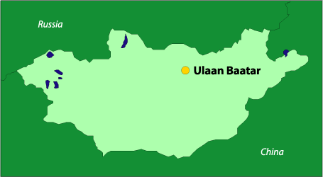
 Much of early history centers itself around an area known as the “Fertile Crescent,” referring to the land between the Tigris and Euphrates Rivers in present-day Iraq. Many ancient kingdoms were borne out of this region, including the Assyrians, Sumerians, and Babylonians–whose legendary King Hammurabi penned the enormously important Code of Hammurabi, one of the most significant legal doctrines of all time.
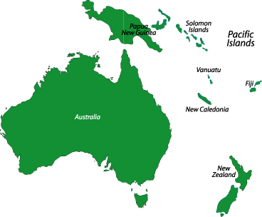
 Papua New Guinea Flag Papua New Guinea makes up the eastern half of the island of New Guinea–the second largest island in the world. It was divided between Germany (north) and the U.K. (south) in 1885. The latter area was transferred to Australia in 1902, which occupied the north during World War I and continued to administer the combined areas until independence in 1975.
 Costa Rica has long been seen as an “eye of the hurricane”–a peaceful nation situated in the center of an often turbulent region. The rich history and well-preserved and diverse environment attracts tourists from around the globe. From its beautiful beaches to its massive rainforest, teaming with wildlife, the Costa Rican government has long been committed to preserve the country’s reputation as a environmentally and user-friendly place to visit.

 Venezuela is a gloriously beautiful country, and with almost 2000 miles of coastline, mountains, and jungle, there is something for everyone. Sites like Angel Falls, the world’s highest waterfall, and Lake Maracaibo, South America’s largest lake, ensure that you won’t soon forget Venezuela’s natural beauty. This is a country of extremes–just check out the giant anaconda for proof; it’s the world’s longest snake, capable of devouring a 100-pound tapir, or even a human, in a single meal.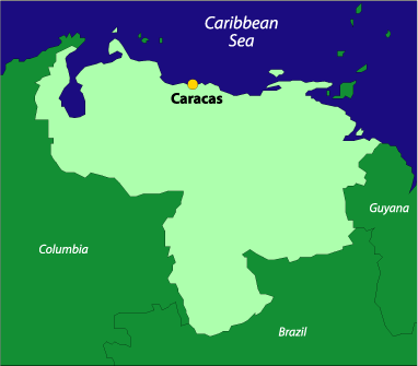

 Compared with the rest of volatile Central America, Belize is more like the island nations of the eastern Caribbean than it’s mainland neighbors. Its laid back way reminds visitors of the way the Caribbean was in the days before the big resorts.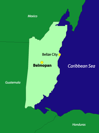
 The sultanate of Oman is a land of friendly people and magnificent landscapes–so the world is finding out as this corner of the Middle East emerges from a long period of isolation. Oman is one of the most traditional countries in the Middle East, but as it slowly comes out of its shell, it’s beginning to look more toward the future than the past.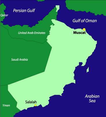
 Population: 2.5 million