I’d been reading about the Baja Ha-Ha, the sailing rally from San Diego, California, to Cabo San Lucas at the tip of Mexico’s Baja California peninsula, and was eager to go. Although I’d been sailing in Southern California for over twenty years, this would be my first long passage and first time south of Ensenada.Preparing Moondance, my 1994 Beneteau Oceanis 400, wasn’t difficult. The boat came equipped with radar and an integrated GPS/chart plotter, a device that combines a satellite-based global positioning system with an electronic map that will show your boat’s position on a chart. Linked to an autopilot, the system can steer a boat to any point on any ocean.
Three months before departure, two of my three crewmembers dropped out for personal reasons, leaving Ed and I to go it ourselves. Ed Redman is a longtime friend and has been my trusty crew since I first started sailing small boats.
Leaving my home port of Long Beach, California, we arrived in San Diego a few days early to take care of last minute rally paperwork, attend the skippers’ meeting, and do a little last minute provisioning. While on the hook (that is, anchor) in the crowded anchorage, we met some of our fellow rallyists and other sailors.
While not part of the Ha-Ha rally, Chris Lolliss had sailed Shan, a classic small engineless wooden schooner he’d built himself, down from Seattle. Bound for the South Pacific, Chris picked up crew where and when he could, but often sailed single-handedly since the boat had little to offer besides adventure. Simple of design and construction, she had no modern sail handling devices and relied on muscle power alone to get things done. With a small cramped interior, there was no head (or bathroom), merely a cedar bucket on deck, and the shower was a black plastic bag full of water warmed by the sun. With our comfortable interior, enclosed head, hot showers (water is heated whenever the engine runs), and TV/VCR, Ed and I felt like true hedonists. We began to refer to Chris as a true buckaroo sailor, and when we invited him for dinner aboard Moondance, he eagerly accepted, glad for a break from his normal fare of energy bars and peanut butter.
Sunset during Baja Ha-Ha
Sunrise over Baja hills
Paperwork finished and meetings over, all 112 boats participating in the rally departed San Diego on October 31, 2000, under sunny skies with the promise of good wind to come. By noon we were in Mexican waters. Filled with a sense of adventure, we made progress, and as the sun set, my first night at sea was about to begin. I had made several night crossings from Long Beach to Catalina Island, about 25 miles from the mainland, but those had started just before sundown and we’d always arrived well before midnight. This was different. We began our watch schedule of four hours on and four hours off promptly at 6:00 P.M.
The start date of the rally is planned to coincide, as nearly as possible, with the full moon, and as the sun set, the moon was already up. As the darkness became deeper and more intense, the moon became brighter until it was a lantern in the sky laying down a long glittering trail of light that we sailed straight down. Alone in the cockpit from 10:00 P.M. until 2:00 A.M., I was almost overwhelmed by the beauty of the night and my nervousness began to fade, only to return around the end of my shift. By now we were fifty miles offshore and when the moon slipped below the horizon it suddenly became very dark. Thankfully, the plotter screen and the instrument lights on the panel in front of me glowed steadily and reassuringly.
On the second day, while hoisting a light-weight sail designed for heading downwind, a piece of hardware malfunctioned, the sail fell to the deck, and the halyard–the rope, or line, that raises the sail–went clear up the mast.
That was a bit of bad luck, but we could still sail downwind with the foresail, called the genoa, set on a whisker pole. A whisker pole is a telescoping aluminum tube, twenty feet long and used to hold the sail out at the proper angle to the wind. We were sailing in a configuration called “wing and wing,” where the genoa is poled out on one side of the boat and the mainsail is set on the opposite side, so the boat appears to have sprouted brilliant white wings as it glides across the sea.
Those first three days were some of the most sublime sailing I’d ever experienced. They were warm, clear, sunny days and moonlit nights. The wind blew a consistent sixteen knots day and night. (To find miles per hour, multiply knots by 1.15.) The boat often surfed the eight-foot swells that rose up astern and we were able to average seven knots, which is very respectable for a forty-foot sailboat.
Mexico
Mexico
During the day we read, listened to music, kept track of our position and wrote in the log. Whoever was awake kept an eye on the horizon as the autopilot steered. Sometimes, just for fun and something to do, we steered by hand, but not for long. Without a visual reference to steer by, it’s difficult to hold a compass course. Your attention wanders, the speed drops, and before you know it, you’re twenty degrees off course. With the autopilot in control, we could watch the digital numbers on the knotmeter rise and consistently stay high.
We soon discovered that a boat making seven or eight knots through the water is not exactly a quiet, restful place. The forward cabin was mine and with it came the bumps and thumps and the loud rushing noise of water moving past the hull, plus the rhythmic creak of the mast and its network of stainless steel support cables, collectively called the rig. Ed claimed the aft cabin for himself, which was subject to the noises of running the boat: the winches when the sails required adjustment, bumps and thumps of moving around, and the creak of the interior woodwork as the boat moved along. After a while, earplugs became our best friends.
Before departure, we had carefully planned the menus and had a full complement of tasty and nutritious food aboard, but we quickly found meal preparation while the boat lunged and surged became a matter of “Just how hungry are you?” We discovered that a bowl of instant oatmeal or a peanut butter and jelly sandwich could fill the holes in our bellies and we started to rely on just one hot meal a day, a dish we came to alternately loathe and love. It wad a one-pot affair made up of a can of condensed soup, a can of water, a cup of rice, and a can of meat–chicken or beef. Brought to a boil and simmered for twenty minutes, it was hot and there was plenty of it.
Ed and I had been friends for a very long time and we knew each other well, but one thing we discovered early on is that we have different styles of dishwashing that are so incongruous, it was impossible for us to work together on that chore. This presented one of the quirks of living in such closed quarters with another person: you learn to adapt your ways in the name of mutual agreement, because if you don’t, nothing works and nothing gets done. We resolved that we’d take turns with the dishes, which included all the drying and stowing, he completing the task his way on his turn, and I mine.
The first stop for the rally fleet was a small isolated village approximately halfway down the coast of Baja California (in Mexico) at a place called Bahia Tortuga, or Turtle Bay. The day before our arrival at Turtle Bay, most of the fleet was on the VHF–a two-way radio for marine use–discussing the pros and cons of the entrance to the bay. Experienced sailors were of the opinion that it was an easy entrance, without too many hazards. “Just be wary of the scattered rocks on the southern headland and stay out of the kelp fields on the northern headland.”
In spite of our best efforts to slow down enough to make a daylight entry, we arrived at the entrance to the bay about 3:00 A.M., after the moon had set. Lighthouses on both sides marked the entrance, but in the pitch dark, without other distance references, it’s very difficult to tell how far away a light really is, and this was third-world dark: an inky blackness so intense it seems to swallow up any light you shine into it. Exhausted from three days of continual sailing and with growling stomachs, we decided not to lay off until dawn and to enter right away. After all, we had all modern electronics aboard… What could possibly go wrong? Bad question. That’s exactly when our radar/chart-plotter screen konked out on us; after several tries, I was able to get the chart-plotter function to come back up, but the radar refused to work.
My chart plotter showed I was too close to the rocks, but I could see anchor lights from other boats already in and I convinced myself that I had plenty of room. So with an eye on the depth sounder we slowly headed toward the lights.
Suddenly, the boat was surrounded by what appeared to be very long, eerily glowing strings of phosphorescence, a kind of spooky sargassum that seemed to be lit from below. Then strange shapes of considerable size appeared in the water and moved with incredible speed and grace. Like glowing torpedoes, they headed straight for the side of our boat, and just before impact disappeared underneath and reappear on the other side. Almost unconciously, I slowed down.
Area of interest
My heart thumping, I looked over the side, wondering what these strange apparitions could be. It dawned on me then that the rope-like material was kelp and the glowing shapes streaking through the water were dolphins lit up by the phosphorescence. I slowed to a crawl.
Despite the chilly night, I broke out in a nervous sweat and sent Ed up to the bow with the 500,000-candlepower spotlight. It wasn’t a minute later that I heard him yell.
“Rocks! Rocks ahead! Hard to starboard, hard to starboard!”
I’ll never forget the note of urgency in his voice, or the sheer dread I felt when I looked where he had shined the light and there, rising up out of the water, was a jagged black rock rimmed with green, the size of a dump truck.
Spinning the wheel, I cut the throttle back even more, suddenly afraid of catching that kelp in my prop. That could trap us there, close to the rocks that were just waiting for an unlucky, or unwise, sailor to stumble upon them. I didn’t relish the thought of going over the side in the dark to cut it away. Fingers crossed, we chugged along. The kelp gradually thinned and the dolphins mysteriously disappeared.
It’s a known fact that fatigue can make a cautious, prudent skipper careless. We’d avoided a catastrophe by the skin of our teeth and I’d made up my mind to head out to sea and wait for the dawn, when we saw the lights of an approaching vessel, undoubtedly another Ha-Ha participant.
This boat was big–around 50 feet–and as it went by I could tell the captain wasn’t feeling his way in like we had been; he knew exactly where he was and exactly where the entrance was, as though he’d been there before. We quietly fell in behind him and headed in to drop anchor among a forest of masts and a constellation of anchor lights.
The bay, set in a bowl formed by the low brown desert hills of Baja, provides good protection for literally hundreds of boats and almost no one passes it without stopping, either northbound or southbound.
To call it isolated is an understatement. Most maps don’t even show it, but it is located just south of Punta Eugenia, the tip of the large horn midway down the Baja peninsula.
The amenities are few; one or two small restaurants serving great seafood, and one tiny hotel. Fuel and water are available, at a price. Almost everyone is employed at the fish cannery or on the local fishing boats. The local residents–especially the kids–look forward all year to the arrival of the Baja Ha-Ha fleet, which brings not only Halloween treats, but donated clothes, shoes, and school supplies. During the huge beach party, many of those local kids earn a few pesos “guarding and cleaning” the dinghies on the beach.
After doing boat chores, which included hoisting Ed up the mast in a special chair to retrieve that errant halyard, we arrived late for the beach party. Beach landings in an inflatable dinghy can be hilarious entertainment for those already ashore. Ed and I approached the beach cautiously, but in spite of all efforts to the contrary, the dinghy managed to get sideways to the small waves and I found myself sliding right off the side into the water. Ed thought that was hysterically funny, but I’d get even with him later. We stayed long enough to drink one beer and then headed back to the boat. After a great dinner, cooked in a galley that wasn’t rocking and rolling, and a good night’s sleep, the fleet pushed on the next morning.
A perfect breeze shaped the sails and the sky was an inverted blue bowl of good weather. As if to add the final touch of magic, a huge pod of dolphin appeared, swimming and leaping alongside and playing in the pressure wave at the bow. We took it as a good omen for the upcoming leg, which turned out to be only partly true. The next day, just at dusk, we were sailing downwind in fifteen knots of breeze, a good speed for downwind work, when suddenly the whisker pole swept forward, pivoted on its mount on the mast, crashed into the forestay, and bent to a 30° angle. With the pole bent and that big sail cracking and snapping in the wind, the mast shook and vibrated the whole boat. The noise was horrible.
Suddenly, I was faced with a situation I’d read about but had never dealt with before. In a matter of seconds we went from a great downwind glide under perfect conditions to an emergency that would steel my nerves. Now I had to leave the relative safety of the cockpit and go forward to deal with a problem in the gathering darkness.
Strapping on a lifejacket and clipping my harness onto a stout line, I slid forward onto the pitching foredeck. I managed to get the whisker pole down and lashed on deck, but in the process, the lines that control the sail tangled themselves into a hard wet knot so tightly, I couldn’t straighten them out. That meant the sail couldn’t be set or rolled up and stowed and was now madly whipping about like an angry beast intent on flinging me over the side. The only thing to do was to wrestle the sail onto the deck as the bow gyrated wildly on the waves. I struggled out there for what seemed like hours but was really only thirty minutes. The sail down and lashed tight, I made my way back to the cockpit, winded and thirsty, but also proud of myself for handling the situation. We continued under the mainsail and still managed to make five knots. At least we were going downwind. If we’d been going upwind, it would have been much worse and we could not have made much progress without that headsail.
Baja Ha-Ha
Group shot from the Baja Ha-Ha
Two nights later, approaching Bahia Santa Maria, I received my introduction to rain squalls packing thirty-knot winds and torrential rain. These squalls rolled up from behind us in the pitch darkness after the moon had set and were difficult to avoid. They averaged about fifteen minutes apiece, but they were intense fifteen minutes.
If Turtle Bay was isolated and sparsely populated, Bahia Santa Maria is absolutely desolate. Also surrounded by low brown desert hills and beautiful in a spare, forbidding way, the bay provides flat water for anchoring, but the prevailing wind sweeps through a gap in the hills and huffs and puffs almost continually. With no permanent residents–only a temporary fish camp–no fuel or supplies of any kind are available. We came into the wide entrance at about 4:00 A.M. during a slashing rain storm and dropped the hook. The hot shower and scrambled eggs were wonderful and I fell into my bunk and slept for at least ten hours.
Many rallyists, us among them, spent an extra day there to catch up on rest, eat a few meals and do minor repairs. In the frantic struggle to get the genoa down, I’d lost the stainless steel shackle that attaches the top end to its halyard. In order to raise it again, I laced the halyard shackle to the sail with a very strong nylon parachute cord.
At ten o’clock on the third evening, we and several other boats departed in order to make our approach to Cabo San Lucas in the early morning, two days later. A twelve-knot breeze blew for the first twelve hours and, with the moon high and bright, it was a truly magnificent sail down the coast, but the next morning the breeze died and we motored the rest of the way to the cape over glass-smooth seas under sunny skies.
Arriving just at dawn, Ed and I marveled at the sheer beauty of the coast there. High rocky tan bluffs, to which grand houses clung, plunged almost straight down into a cobalt-blue sea ringed with frothy white waves crashing on shore and the sky was so blue, it seemed to have been painted that way.
Rounding the rock formation known as Los Arcos, or The Arches, we headed in to the inner harbor for fuel and water. These distinctive rock formations have been a navigation landmark since the Spanish treasure galleons sailed from Manila in the sixteenth century. Sailing north a few degrees latitude, they headed straight across the Pacific until they reached the North American coast; when they spotted Los Arcos, they knew where they were and what the course to Acapulco was.
In the last twenty years, Cabo has grown from a small fishing village to a major tourist vacation destination. It is also home to one of the worlds largest sport fishing fleets. The inner harbor is chockablock with gleaming, foreign-owned boats and space is very expensive. I knew we’d have to drop the hook in the outer anchorage, which is, in reality, a rough and rolly open roadstead over a sloping shelf of sand that is constantly sliding into the deep submarine canyon that lies just offshore. This was where the fun started to leak away.
In getting the hook down, we began to experience a severe vibration in the engine and the recommended mechanic, an American expat named Kenny, diagnosed a transmission problem. Removing the transmission, he took it back to his shop and gave me the word the next day.
“The clutch discs are shot,” he proclaimed. “Have to order new ones from San Diego.”
Don’t worry,” he said when I turned pale, “I’ll have you out of here in a week, ten days tops.”
Ten days turned into fifteen days. I was burning up my vacation time, not to mention our stores, and I was beginning to suspect some kind of scam. The parts did arrive in Cabo but Mexican customs wouldn’t clear them into the country.
While anchored in the open roadstead off Cabo San Lucas, we became resource management experts by necessity. We had taken on fuel and water when we arrived, but after two weeks, water for showers and dishwashing was running low. We used bottled water for cooking and had saved one three-gallon jug and several one-gallon jugs, giving us a ten-gallon transport capacity. Loading all the jugs into the dinghy, we made the two mile run into the marina. Since the water faucets all had removable handles, we had to find someone aboard their boat and ask them if we could fill our jugs, which we would then take back to Moodance and pour the contents–one at a time–into the water tank. This had to be done at least every third day.
Anchored right off the main beach that hosted the big resort hotels, we became very familiar with the resort activities. The parasail boats–large, powerful inboards–appeared each day about 9 A.M. and raced around until sundown. These boat threw large wakes that rocked us constantly, and they passed so close that at first I was concerned they would tangle their tow line in my mast, but it never happened. All the hotels rented jet skis, which buzzed and circled us from dawn to dusk like huge angry mosquitoes.
Mexico
Mexico
I had quite a collection of music aboard, but after a few weeks we’d heard all the CDs so many times we knew all the lyrics, and suffered the same fate with the two dozen or so movies we’d brought. When Ed found a video rental place, I agreed to a nightly movie, which had the added benefit of improving our Spanish, since the dialog was in English with Spanish subtitles.
Spending so much time in the anchorage did have one advantage: we met a lot of people. I woke one morning, came up into the cockpit with a cup of coffee, looked around and thought I recognized a new arrival. Chris Lollis had arrived on Shan. He’d had a terrible run from Turtle Bay, he said, and lost his pretty little home-built dinghy in the bargain. Fortunately, he was able to buy an inflatable one from a cruiser that had a spare. To add insult to injury, his pocket was picked that very night.
We met many cruisers, but, since Ed and I were two guys on a boat, we tended to spend time with other guys, those sailing solo or with one or two crew. Stephen Mann had sailed to Hawaii from San Francisco in a race for singlehanders and had placed well in his division. Now he was back, planning on spending a few weeks in Mexico before sailing back to San Diego, where he was employed as a professional rigger. A cruising veteran who had been up and down the West Coast of North America many times, he was fluent in Spanish. His boat, a Wylie 39, was a model of efficiency on deck, with most of the creature comforts down below: microwave, TV/VCR, a well-equipped galley, and the most extensive CD collection I’d ever seen on a boat. He also had a robust autopilot that could have steered the Queen Mary.
We met the couple sailing Illusion, the thirty-four-foot steel-hulled boat they’d built themselves. Bob and Stephanie were from the Pacific Northwest, both expert sailors, and planned to spend a season or two in Mexico before heading out to the South Pacific.
We also had plenty of time to observe the local flora and fauna around us, which included the water we floated in. We were in one place for so long that a marine ecosystem began to form under and around our hull. Barnacles and other small crusty creatures appeared right at the water line. Small fish showed up to feed on these organisms, and larger fish appeared to feed on the smaller ones, until soon we were able to watch the daily struggle for survival as the bigger ones chased the smaller, and on down the line. Once we saw two manta rays leaping out of the water over and over as they swam side by side parallel to the beach.
In the evenings, as the land cooled, the wind would shift and swing the boat on its anchor so the incoming swells would strike the boat on its side, making us rock back and forth so hard things fell off shelves and out of lockers. We became experts at deploying the stern anchor from the dinghy to keep the bow into the waves and so turn the rocking motion into a pitching motion, which is easier to take.
Cruise ships anchored about a mile from us, and I frequently spoke to them by radio to get weather reports. When a cold front rolled through with wind and rain, I didn’t get much sleep for three days, because we were anchored on what’s called a lee shore, a condition where the wind blows you toward land. If my anchor began to drag, or even broke free from the poor holding ground, I would have to sail the boat out to sea and out of danger. Fortunately, the anchor was well set and we didn’t move.
On the twenty-seventh day in the anchorage, I started the engine to recharge the batteries as usual. There seemed to be more vibration than usual that day, and in looking things over, I noticed by the tachometer that the idle speed was a little low. When I adjusted it, the vibration disappeared. Very suspicious of that mechanic and tired of the moribund Mexican bureaucracy, I had him reinstall my old parts with new fluid. The transmission has worked perfectly ever since.
Area of interest
Time was running out, but I still wanted to get to La Paz (“The Peace”), so fueled and watered, we departed Cabo early one morning. With no wind and short on time, the plan was to motor to La Paz in one twenty-four-hour passage. Rounding the corner into the Sea of Cortez that afternoon, the wind was suddenly twenty knots out of the north, with six foot seas. We had to slow to three knots to avoid pounding into the waves. Passing the anchorage at Los Frailes, I had a notion to head in and drop the hook, but we were making reasonable progress and decided to push on.
Late that night (isn’t it always), Ed woke me out of a sound sleep with the news that the genoa was starting to unroll from the inside, a dangerous situation. Getting that sail down on the plunging bow with the dark water only inches away was a thrill I’m not anxious to repeat.
In La Paz I opted for a slip in a marina, and the Marina de La Paz was just the ticket. The staff took care of the Mexican government paperwork procedures, for a fat fee, and the café was good and convenient, if not exactly cheap. Four days in the marina zipped by and it was time to head out again, only this time, we were headed home, pushing to make it by Christmas.
Nervous about the “Baja Bash” as the trip up the coast is called, I’d been monitoring my fuel consumption and went over the figures again and again. The conclusion was always the same. Even with the measures I’d taken, I didn’t have the fuel capacity to make Turtle Bay from Cabo. The marina store was sold out of five-gallon jugs, but the big hardware store in town had two, along with two six-gallon polyethylene water jugs. Combined with the fuel bladder I had, these brought my fuel capacity up to eighty gallons.
Departing Cabo in mild conditions, we pushed for two days and nights into a wind that steadily increased until it was twenty knots dead on the nose. The Perkins diesel was burning fuel like mad, and we were down to the last tankful with still too many miles before Turtle Bay. Suddenly, the engine faltered. Switching the fuel filters brought it back, but the alternator chose this moment to head south too. As we passed between the headlands of Turtle Bay in the gray dawn, I crossed my fingers for the engine, but when it faltered again I expected it. As luck would have it, it came back long enough for us to get into the bay and get the hook down.
We blew a day on rest and food and the next morning, I attacked the engine. Within an hour, I had checked all the filters and bled it (removing air from the fuel system) thoroughly. It started right up and ran at a fast idle for twenty minutes. Problem solved, I thought. I purchased eighty gallons of fuel and prepared to get underway.
Seven o’clock the next morning found us San Diego bound, but just between the headlands of the bay, the engine again began to stumble and soon died.
We quickly unfurled the sails only to watch them flap uselessly in the still air of early morning. The rocks–the same rocks that had scared me on the way down–looked blacker and sharper than ever, until we put the dinghy back in the water and used the outboard to tow ourselves back to the anchorage.
An enterprising mechanic came out to offer his services, but I declined and went over the systems again. The engine ran for forty-five minutes and never missed a beat. “We’re out of here!”
Anchor up, we again headed for the entrance, but we didn’t make fifty yards before the first stumble, and very soon, with a resigned shudder, the engine quit. I began to get an inkling that there was more than met the eye here. I managed to get it running again, but when I tested it under load it quit yet again, and I hired the mechanic.
Cero did everything I had done, with the same results, and I began to take a perverse satisfaction in his failure. See, I told myself, it wasn’t that simple. A few hours later, the whole fuel system was in pieces. The main salon and the aft cabin, Ed’s living space, was strewn with tools, chunks of rubber hose, fuel filter elements, plastic tape, and other detritus; and the smell of diesel fuel hung in the air like a fog.
Fuel Pump
Moondance’s rebuilt fuel pump
Cero worked for about eighteen hours over three days and determined the problem to be a lift pump fouled by debris left over from the Racor filter installation. Of course, I didn’t have a spare pump, and he didn’t have one to fit. I had visions of us trying to order parts from San Diego again, with all the attendant problems of distance, time, money, and Mexican officials. I mentioned to Ed that it seemed like it might take many days, even weeks, to get back home. I had to stay, as it was my boat, and because I was self-employed and had no boss to worry about, I knew staying was an option not out of the realm of possibility. Ed drove a cab for a living and could take all the time he needed, but I also knew he very much wanted to be home for New Year’s Eve, a lucrative holiday for cabbies. I told him he could get on a bus if he wanted to, and I’ll never forget his reply, which was shrouded in Ed’s unmistakeable sense of humor.
“Do you know the difference between ‘involved’ and ‘committed’?” he asked.
“No,” I replied. “What is it?”
“In a bacon-and-egg breakfast, the chicken is involved,” Ed paused for effect, “but the hog is committed. I’m like the hog. You and I are going to get this boat back to Long Beach, whatever it takes, never fear about that.”
We shook hands on it and soon thereafter, in the best tradition of make-it-work-with-what-you-have, Cero cobbled together parts from various sources and came up with a working pump that fit my application. He’d also taken my finicky and troublesome alternator to his shop, where he performed ministrations on it that had it working again.
When he was finished and the test, which had us powering around the bay in the dark, proved successful, it was time to talk money. Just so there would be no mistake, I handed Cero a pen and paper and he wrote down a number.
“Pesos?” I asked, thinking I had it covered.
“No,” he replied indignantly. “Dollars! Muy trabajo. Much work!”
Three hundred bucks! I simply didn’t have it in cash. I showed him credit cards and a drivers license, and promised to send him the money, but to no avail. He wanted his money now. There are no ATMs in this tiny little town and the Western Union office can’t receive wire transfers. The closest bank is a twelve-hour bus ride away, then twelve hours back. I had visions of Mexican jails, the boat impounded, Ed and I stranded on the beach, but Ed had an idea. Cero was not happy about it, but he could see his options were limited, too. I ended up trading him my nine-inch color TV/VCR, my spare handheld VHF marine radio, and some other electronics for his work.
This is where I got back at Ed for laughing at my earlier beach-landing efforts. Ed took Cero ashore in our dinghy. When he returned and was boarding Moondance, he let go of the wrong line and turned to see the dinghy blowing away in the stiff breeze. Since they are very light for their size and have almost nothing under the water, inflatable dinghies blow away very fast; ours was already twenty feet away. Ed began to shed shoes and clothes and, down to his skivvies, he dove after it, swam at top speed and managed to catch it about fifty feet away. He climbed in, started the engine and motored back, wet, cold, and haggard from the exertion. Knowing he couldn’t tell the story about my dunking without hearing about his too, we declared a truce that was mostly observed.
Northbound once more, the weather turned to low clouds and mist pushed by a twenty-knot wind with an eight-foot swell, and again we had to reduce speed to keep from pounding the hull into the oncoming waves. It was December 22 and we were making less than four knots over the bottom. It would be a miracle if we made Long Beach by Christmas.
Forty-eight hours after leaving Turtle Bay the alternator packed up again, taking the engine panel gauges with it. We were slowly draining the house batteries and the engine seemed to have an even more voracious thirst for fuel. Slowing to three knots, we tried to conserve what little fuel we had left. Ensenada wasn’t too far, but in order to make a daylight passage of the southern entrance, we needed to slow down even further.
Participant
Another Ha-Ha participant
Once again we were hungry, cold, forced to go slow, and, unable to generate power, we couldn’t help but wonder what piece of equipment would fail next. Late that night, I woke early for my watch and began to feel an odd stirring deep in my gut. I ignored it and tried to go back to sleep, but in the next several minutes, it became worse, until, unable to lay still, I had to get up.
Moving up into the cockpit, I slumped onto the seat and couldn’t stifle the groan that escaped. It felt like my insides were being twisted into knots and another involuntary groan escaped.
“Are you all right?” Ed sounded calm.
“I don’t know,” I said. “My stomach hurts.”
Another groan boomed forth as I grabbed my middle. This didn’t feel like mal de mer, nor did I feel hungry, although I’m sure I must have been since we nearly always were. This was more like a twisting, grinding sensation that made a cold sweat break out all over me. I groaned again.
“Should I try to radio the Coast Guard?” Ed wanted to know.
“No,” I replied, but deep down I wondered if that was the right decision.
After twenty minutes of torture and more groans, I had an idea. I asked Ed to bring me a one-litre bottle of ginger ale and a box of crackers. I began to munch Ritz crackers four at a time and wash them down with mouthfuls of Canada Dry. It’s well known that the ginger in ginger ale will ease stomach pains and relieve nausea, and after a while, I began to feel a little better. I sent Ed below and before my four-hour watch was over, the box and bottle were both empty. At dawn, Ed came up to relieve me and asked how I felt.
“Better,” I said.
“You had me worried there. What made your stomach hurt so bad?”
I had no idea. Suddenly, the autopilot began to wander off course, and over the noise of the engine and wind, I heard a new noise. Peering into the locker where the drive unit for the autopilot was, I could see it working back and forth and hear it groaning, as if it too had a belly ache. I turned it off.
It’s been said that cruising amounts to fixing your boat in exotic locations. There’s a great deal of truth to that statement. It wasn’t a happy ship that was slowly plodding northward. Ed and I alternated steering. It was exhausting trying to maintain a compass course at this very low speed, then suddenly Ed leaped to his feet. My immediate thought was that something else had gone wrong, but Ed looked at me. “I know what we need,” he said.
“What?”
He said nothing, only grinned and went below. I wondered what he was doing down there, but forty minutes later the aroma of frying bacon lifted out of the hatch and I felt my spirits lifting with it. An hour later Ed appeared, carrying a plate piled high with pancakes, corned beef hash topped with a fried egg, and a huge serving of bacon.
“Had to cook all the bacon,” he said. We’d shut down the refrigeration to conserve the batteries and it was starting to show. “I’ll take the wheel, you eat first.”
I was stunned. I knew that before Ed could cook up this glorious feast, he had to clean the galley–no mean feat in these conditions–but he’d done it, and I began to gratefully shovel it in. Breakfast never tasted so good. When I finished I took the wheel back and Ed brought his plate up from the oven.
Suddenly, we had a new outlook on things. We were still afloat, the rig was still up and the engine was running. We were on course and making progress–slow progress to be sure, but moving in the right direction. I began to ask myself: Do I want to spend the rest of today and all of tonight out here, steering by hand, with the possibility of the navigation lights failing and the engine quitting, or do I want to head into Ensenada at best possible speed? After all, the southern entrance is 2.5 miles wide and marked by two lighthouses. We decided to go for it.
That night was one of the darkest I’d ever seen. A heavy mist, blown about by the wind, seeped into everything. Approaching the entrance, I took stock. With the chart plotter down and the batteries too weak for radar, I had paper charts spread over the cockpit table and the handheld GPS in my hand. The southern light, on Punta Banda, glimmered through the misty darkness. Thirty minutes later, another light shimmered through the gloom ahead of us. According to the chart, there should be three lights, one on the southern tip of Islas de Todos Santos, a revolving light on the smaller island to the north, and a light on Punta Banda, but we could only see two. The revolving light on the small northern island was invisible even though it had a range of twenty-two miles.
Scanning the cruising guide once again, I noted the mention of a red light atop a tall radio antenna southeast of the southern headland. Ed’s keen eye quickly picked it out. Very nervous, damp and chilled to the bone, I nipped below to use the head. On the way back I paused at the DC panel to check the battery voltage and pondered that old saw about there being no atheists in fox holes. Nor in cruising boats, I added, then I asked the powers that be to watch over us and see us into the anchorage at Ensenada.
Back in the cockpit, I plotted one more position, checked the lighthouses and caught the loom of the revolving light on the underside of the clouds. The “X” of the plot hovered at the center of the entrance and we made our turn. The lights on both sides of us slowly moved aft as I plotted the course for the harbor entrance at the head of the large bay.
Moving through the cold, damp darkness, I spotted what looked like a huge pile of rocks off starboard, but the chart showed no such rocks and the depth sounder was mindlessly blinking the same number over and over. The spotlight beam that spotted the rocks at Turtle Bay was now swallowed up by the murky gloom.
Looking for the red and green lights of the harbor, we slowly moved ahead. What, I silently wondered, would I do if the engine suddenly quit–out of fuel or from some other cause? Contingency plans began to pop into my mind. Drop the dinghy and try to tow the boat into the harbor. If the outboard ran out of fuel, I planned to let the main anchor and all 200 feet of chain go out, hope it snagged the bottom before I went on the rocks and at the same time call for help on the on-board VHF.
Skipper
Skipper at the helm
Suddenly, the clouds seemed to part and there they were: millions of lights spreading in lines and patterns up and down the hills. To spot the harbor, we looked for the lights of a cruise ship, but none were visible. There was, however, a line of glowing orange orbs that seemed to hover in mid-air that I recognized as the malecon, the promenade that runs next to the harbor. Soon the flashing green light that marks the left side of the entrance blossomed out of the dark, followed quickly by the red. Turning into the harbor, I was mildly shocked to see how much it had changed in the six years since I’d been here last. It was Christmas Eve, and every Mexican Navy ship within several hundred miles was in port; we slowly motored through a watery landscape of silent mist-shrouded gray shapes.
Seeking the transient yacht anchorage, we looked for other sailboats, and finally dropped anchor at 11:15 P.M.
Sitting in the cockpit with a cup of spiked cocoa, we waited for midnight. When it came, the fireworks, explosions, horns and sirens that announced Christmas Day was truly stunning–a sight and sound spectacle I’d never seen in the U.S.
Christmas Day dawned cool, bright and sunny. The enormous Mexican flag at Bandera Plaza slowly unfurled and collapsed, over and over, like a gigantic sail in the building offshore breeze. The malecon was thronged with people in their holiday best. No work was done that day.
On the 26th, the boatyard of Baja Naval directed us to come alongside the staging pier. Robert in the office and Rogelio the dock master are both super guys who put themselves out time after time to make sure we were taken care of in a timely manner.
Moored to the staging pier, we had a front row seat for the goings on. Baja Naval has become the boatyard of choice for larger boats in Southern California to come and get work done, and they specialize in paint of all kinds. Ed and I watched a sailboat of classic design tie up nearby. The Evelyn Roberts had been sailed down from Seattle by her owner Tom Roberts. He was on his way to further adventures in warm, sunny Mexican waters and had stopped in Ensenada to do what’s called a bottom job: apply a special growth-inhibiting paint containing ground copper to the boat’s bottom. Since he was a singlehander, we invited him for a sundowner and ended up exploring much of Ensenada together over the next four days, while work was done on Moondance. Baja Naval, located near the heart of the city, made everything convenient and to my pleasant surprise, the yard bill, for alternator work and fuel, was very reasonable. Repaired, refueled, and ready to head north once again, I checked the autopilot and found the problem to be a bit of stray metal too close to its electronic compass. That taken care of, the run to San Diego was a cake-walk motor in cool, clear, sunny weather.
Entering San Diego just after dark, we tied up to the Harbor Police Pier to clear customs and get a slip assignment. Customs formalities were minimal and after a simple dinner, we turned in early.
The run to Long Beach started in great weather, but off Newport Beach thick, gray fog closed in. With the alternator now working, I turned on the radar. Returns popped up all over and I was very glad of the clear-weather practice I’d done. Large fast-moving blips approached to within a mile then curved away, invisible in the clinging gray blanket. Other blips appeared on the edges of the display and slowly moved one way or the other. A tug towing a barge crossed our bow about a half-mile off and we never saw a thing, only two blips that stayed close together all the time.
Approaching Long Beach, we spotted Queen’s Gate on the radar and made one small course correction. I’d never been so happy to see the sickly yellow port lights of Long Beach in my life.
Passing through the gate and into the Downtown Marina, we shut down the engine at 9:30 P.M. on December 30, 2000. After two long months we had not only survived our first Mexico trip, but gotten an incomparable education in the process. When asked now, would I do it again?, I think, Absolutely… But I’d head out to the Channel Islands for a shakedown cruise first.

 The newly independent nation of Georgia is hard to describe in terms of one particular region. Some consider it part of the Middle East, others Europe, and still others Asia. The reason for this may be because it is so closely related, both geographically and culturally, with all of these places. Once it broke from the former USSR, Georgia suffered some civil unrest, but as the situation stablizes, Georgia is becoming a major player in world affairs.
 Georgian cuisine involves many common ingredients, but due to variations in recipes and combinations of its “obligatory” ingredients–such as walnut, regional herbs, garlic, vinegar, red pepper, pomegranate, barberries, and more–each dish takes on a unique taste and aroma, which make Georgian cuisine very popular. Georgian food typically involves an abundance of different kinds of meat, fish, and vegetables, various types of cheese, pickles, and seasonings. And the meals themselves are huge: four, five, or more courses; and it’s considered impolite to not accept food when offered.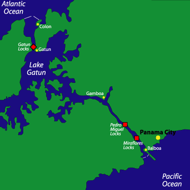
 The answer to the engineering problem that de Lesseps’ original team faced was actually in front of them the whole time. When the French government originally took bids on plans for the canal, one of the top engineers of the time–a man named Baron Nicholas-Joseph-Adolphe Godin de Lépinay–had suggested, instead of a sea-level canal like Suez, that they build an above-ground canal involving locks and artificial lakes for water transfer. A victim of his own pride, de Lesseps ignored this alternative suggestion and went ahead with his sea-level plan. When the Americans started work, they saw value in the notion of an above-ground canal. It was the best way. The idea was to make use of a tremendous amount of water by creating an artificial lake in the middle of the isthmus and a series of locks leading up to and away from that lake. Gravity would do all the work in filling and emptying the locks as needed, depending on the direction of travel.
 At the time of the canal’s construction, Panama was not an independent country, rather it was part of Columbia. As the Americans became involved in the project, President Theodore Roosevelt supported the plan to keep the canal roughly where the French had started it, in Panama. There were many calls from Congress and the public to move the site to neighboring Nicaragua, where the project could be restarted with a clean record, but eventually–with the support of engineers, politicians, and business people–Roosevelt won out. When the Columbian government objected to the American presence in the region of Panama, sending troops to quash local support for the United States, the president encouraged and then formally supported a revolutionary group that created a new independent Panama in 1903. Roosevelt took his payoff in the form of a generous ten-mile-wide Canal Zone, which was administered entirely under the American government. When the original treaty expired in 1978, Jimmy Carter turned the zone back over to Panama, which now operates the canal exclusively (though Americans continued in a few supervisory rolls into the 1990s).
 The greatest problem for the Americans was the cut–the high ground in the middle part of the isthmus (actually about three-quarters of the way through from the Atlantic side) at the Continental Divide. Going through the canal today, you will see walls somewhat higher than a cruise ship, reinforced with bolts and heavy screens. Originally the land was almost 200 feet higher at this point (bearing in mind that a boat floats roughly 83 feet above the lake bed). The plan was to make these walls steep, like the Corinthian Canal in Greece. Photographs taken at the Panama Canal’s opening reveal considerably higher walls than you will see today, but a tremendous slide closed the canal soon after it was officially opened. The ground at this point consisted of layers of slippery shale and a loose conglomerate that easily absorbed water and became mudlike, allowing the shale to slide much like snow and ice in avalanche conditions. Looking beyond the current walls, you can see that the land is fairly flat for a considerable distance. This land was originally much higher than in the cut itself, offering some idea of the huge amount of material that had to be removed to stabilize the area. The work was done like a large open pit mine, with terraced flat areas on which huge steam shovels picked up loads of earth and dropped them into railroad cars, the tracks being continually stretched and rebuilt as progress was made. That one of the original backers of the American plan to keep the canal site in Panama was also part owner of the Panama Railway Company is no coincidence. There were many such cross-interests among the canal’s management and supporters, which had the effect of making them even richer.
 The canal is built with three all-together steps up at the Gatun Locks on the Atlantic side, and one- and two-step locks on the Pacific side, with the mile-long Miraflores Lake in between. There is a marina on the left-hand side, but not much else on this lake. As I understand it, Gatun Lake is very clear and beautiful once off the traffic path. It is a huge body of water, stretching back well away from the main traffic lane into many nooks and crannies.
 The most famous feature of the canal is the system of trains operating on either side of the locks. The original concept for these trains was to pull ships through the locks while their engines were off. The fear was that a ship could get caught in gear, not be able to stop, and ram one of the gates, spilling out the water and closing the operation until the gate could be fixed and the water level raised. It’s easy to imagine this happening at the three-step Gatun locks, causing a massive flood of the entire lake rushing into the Atlantic. As an extra precaution, there were once huge chain brakes stretched across the locks. These precautions have now been eliminated. The chains are gone and ships get in and out of the locks under their own power. I suppose engines were less reliable in the old days, but today the risk of such an accident seems remote.
 As you come out to the Pacific, you pass under the soaring transcontinental bridge and then pass a breakwater on the left several miles long. This is the refuse from the Pacific-side construction. It is the largest and longest breakwater I have ever seen, and again reminds me of the immensity of the job.
 Situated about 575 miles southeast of Miami, the Turks and Caicos make up a Caribbean archipelago with few people and a long history. The original residents of the Turks and Caicos were the indigenous Tainos; however, as in much of the rest of the region, these peaceful people were driven into extinction by war and disease, in large part by way of the arrival of Europeans in the post-Columbian era. During the height of the colonial times, the island group was handed off between the English, French, and Spanish, never remaining a possession of any one nation to develop a positive identity. In the mid-1600s, an industrious group of Bermudians emigrated to the Turks and Caicos to find their fortune peddling “white gold,” that is, salt. Many of the salinas, or salt ponds, mills, and historic structures can still be found scattered throughout the islands. The market for salt from the Turks and Caicos disappeared for good in the 1960s, but for a time during the 1600s and 1700s, these man-made salt flats dominated production and export of the substance around the world, the main recipients of which were the cod-fishing communities of the northeastern North American colonies.
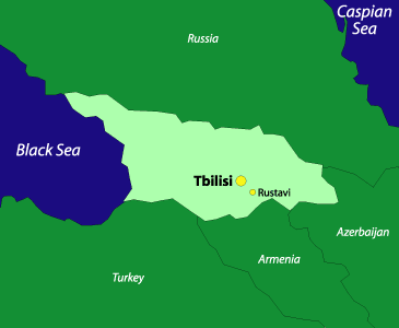
 Waiting in line for customs clearance in Tbilisi International Airport, I thumbed through Rustaveli’s well-worn epic, relating especially to line 899: “So I resolved to wander, for life in the cave grew irksome.”
 The first day was much warmer and sunnier than I had expected. Beautiful skies promised crisp fresh air; however, driving with the windows rolled up on congested Rustaveli Avenue to the appropriately named Tbilisi Restaurant, I discovered that Georgia is the land that the catalytic converter forgot. Almost every vehicle belched out huge clouds of black smoke. But combined with the ubiquitous cigarette smoke in all vehicles, the exhaust fumes were a welcome relief.
 Within Tbilisi, there are many museums to visit, albeit most without electricity and with guides who speak only Georgian, Russian, and German. There are also many historical sights to visit, including ancient fortresses and spectacular churches.
 Today, Westward-looking Georgia is in the news because the United States has sent in 100 military advisors to Tbilisi to train Georgian troops to fight terrorism. The U.S. has also given $1.5 billion in the past few years to improve the infrastructure, specifically the roads in the country. In Tbilisi, now free from marauding invaders but rich in history, it is best to strike out on your own and walk the hills of Old Tbilisi. Explore the narrow cobblestone lanes; numerous open parks; and the unique combination of Georgian, Arabic, and Soviet architecture.
 The Tergi River was swollen from the spring melt and all along the road we saw horses and mules drawing heavily laden carts with people steering from high above. Alongside the famous route through the Caucasus–the Georgian Military Highway–peasants sold sheepskin hats, multicolored woven skullcaps, fresh fruit, and the ubiquitous churckhela, a candy made from boiled grape skins and walnuts. Medieval stone watchtowers from the days of the Silk Road were still prominent on both sides of the valley.
 We spent a few hours working out the kinks from the bumpy ride and ate a traditional multicourse Georgian lunch before embarking for Kazbegi and the family home. This was a smart idea since we found out only upon our arrival that the Russian-owned Intourist Hotel in Kazbegi had been closed for about a year.
 In the years since the Communist Revolution, the public face of China has been very difficult to read. Politically and economically, it has appeared at once uniform and homogenous, standing by a staunch Maoist line and keeping all non-oldguard ideas at bay, as well as open and curious about western capitalist opportunities, modernism, diversity, and cooperation. In the west, China has been viewed as somewhat of an enigma: suppressing freedom of expression and communication (the Chinese government is infamous for extreme censorship of any and all media), openly violating globally accepted standards of human rights while claiming ignorance or slander, and military posturing that is meant to discourage nations such as the United States from looking too closely at what goes on behind their closed doors; all the while urban Chinese are quickly embracing modern technoloy and communication methods such as the Internet, cities have turned into boomtowns where everything is for sale, and the Chinese government has made efforts to draw in western industry and capitalize on business and growth that would send them in a direction opposite the Communist ideals of Chairman Mao and his Cultural Revolution.


 In 2001 my boyfriend and I traveled to the United Arab Emirates (UAE) to visit a friend who had been working there since 2000. Realizing an opportunity to tour this unique Arab nation with someone who knew his way around the place wouldn’t come again soon, we began the tedious process of obtaining visas and invitations from what would be our host country for a few weeks that winter.We arrived in Dubai, one of the seven emirates in the UAE, after stopping in Zurich and Saudi Arabia. What we found was a city that seemed to grow even in the short time we were there. Dubai is an emerging tourist destination and apparent refuge for expats in the heart of the Middle East. At its core, it is a symbiotic blend of opposites: camel races occur every Friday, women are veiled, the ruling Sheikh Maktoum bin Rashid Al Maktoum has six wives (but only five palaces), and drinking alcohol is forbidden if you are Muslim; yet cell-phone-talking, sports-car-driving nationals proliferate in this city where some of the most daring and original examples of modern architecture–including the Burj al Arab, the ambitiously tall hotel that towers over every other hotel in the world–stretch skyward in defiance of old ways. Presumably the significant expatriate population, combined with Dubai’s openness to visitors makes it a city with a consistently malleable personality.
 When I woke up the first morning, groggy and out of sync with the inordinate amount of sunlight streaming into my room, I was immediately awed by how well tradition merged with an unceasing desire to be modern. At first I was jarred–though, eventually calmed–by the sound of a nearby bell ringing. I looked out the window and identified the source of this sound: a beautiful, tall mosque with delicate minarets perched atop round foundations. A moment later, I witnessed a Ferrari racing past our building. It took a few days, but I quickly grew accustomed to this juxtaposition. Dubai has built an aggressively modern city while clinging to important traditions. Religion, predictably, has a prevailing influence. The call to prayer is itself meditative, as bells chime men and women throughout the city toward their religion five times daily. Since non-Muslims are not allowed inside places of worship, I could only peer in after the devout dozens unbuckled their sandals and entered to pray. Perhaps the mosques retain their mystery that way–I am unable to imagine what exactly draws the majority of a country inside to prayer and meditation each day, and while the answer may not be found within those hallowed walls, admittedly, I found myself curious for a look.
 Though the mosque was off limits, I could explore the rest of the city freely. Dubai expands along both banks of a long and famous creek, and its central business district is divided into two parts: Deira on the northern side of the creek, and Bur Dubai to the south. Each side is full of mosques and busy souks (markets), impressive buildings, shopping malls, hotels, schools, and residences. Outside this center, the city extends to the neighboring mercantile emirate of Sharjah to the north, and south and west along the Gulf, through the more conservative emirates of Abu Dhabi, Ajman, Umm All Quwain, Fujairah, and Ras Al Khaimah. Each emirate has a distinct personality, and Dubai is the most westernized and open to tourists.
 Huge sacks of spices flank the walls of interconnected open-air markets. I loved this place. Strong smells of coriander and fenugreek wafted through as veiled women negotiated and wide-eyed tourists searched for unique souvenirs. In true Dubai fashion, markets found their opposite across town in huge modern shopping malls, boasting boutiques full of Chanel instead of coriander. Supposedly, the women in Dubai love to shop and wear designer clothes under their traditional dress, and if the sheer availability of designer wear is any hint, in addition to the number of gorgeous heels I saw poking out from beneath drab burqas, this rumor may be true. Compared to its neighbors, the UAE is not as restrictive of its women. Women can drive. They are educated. They sometimes hold jobs and are often not entirely covered. Men typically wear a white, loose-fitting garment that floats to the ankle, called a kandoura, or dishdasha. The women’s robes–or abayahs–are similar, but colored black. Men and women both wear head coverings (for men the gutra, for women, if it also protects the face, the burqa) ostensibly to protect them from the sun. The patterns and colors of the men’s head coverings reveal a man’s homeland, but a woman’s is simply black. Women in Dubai and throughout the UAE wear makeup and jewelry, and sometimes paint themselves with henna, in intricately beautiful patterns. I wish women in my family had such a custom. I grew up in a small town in New England; as a child, I wasn’t even allowed to wear eye shadow, never mind such detailed and artistic patterns in ink, painted all over my hands, arms, and forehead. It’s painstaking work to paint these designs; it takes time and great patience, which seem to translate easily in this special art.
 Dubai entered its current period of swift growth in the late 1960s and early 1970s. Much of its current architecture was built only a few decades ago, and just occasionally will you witness one of the old wind towers, an early form of air conditioning in Dubai. This tactile sense of modernity and sudden growth is evident throughout the city, so much so that when I encountered an older building, such as a mosque that had been standing since the nineteenth century, I did not quite know quite what to make of it. Many of these “artifacts” were exciting to me simply because of their rarity. There is one historical and archaeological museum in the city that contains Bedouin-crafted clay pots, the remnants of original buildings, evidence of the pearling industry, and memories of a more nomadic culture. Touring this museum meant leaving the present Dubai behind. The museum chronicled the city’s growth from its early days as a stop-over destination for nomadic Bedouin tribes, to its period under British protection, to its discovery of oil just a short time ago–the majority of the pictures are post-1960s. I had never before seen a museum with such a bereft historical record. There is still, however, the palpable feeling that Dubai did not grow up all at once, but rather out of a tradition. And there are pieces of that tradition and elements of pre-oil Dubai, as a center for trade and fine crafts. Dubai still has some of the most beautiful and heavily traded gold in the world. The neighboring emirate of Sharjah still trades rugs that are handmade by families who have been honing that craft for generations. But Dubai is consistent in its contradictions, as evidenced by the rivaling billboards near where I stayed: one, a picture of Sheikh Maktoum waving and reminding all of his power; the other, an advertisement for the Gap, encouraging individuality through denim and striped scarves.
 As a sports spectator, those traveling to or living in Dubai have options. Weekly camel races occur each Friday and last hours. Tiny young boys are recruited from nearby places to ride animals I’d never thought of as speedy. But the camels are fast, and the boys are light, and somehow the hours pass as the humps stream by with little arms and legs keeping hold atop them. After one race, my friends and I talked to a few of the riders and camel trainers. My host, who fortunately speaks Arabic, related the praise one trainer spoke of his animal and about how fortunate the boys are to ride them. According to the trainer, it is very lucky to be chosen as a camel rider because your family is paid well and you achieve social status. Many families, trying to take advantage of this opportunity, move from a less desirable country to live in Dubai. Many of the young jockeys were from Bangladesh and would earn more money in one race than their fathers did in a month of labor. I never decided if I thought this was good or bad. The boys, we learned from our friend, woke early, trained hard, and were forced to live apart from their families for long stretches of time. Very few of them were more than nine years old, and many people view the practice of putting these children through the hardships of this lifestyle as unjust. On the other hand, their quality of life apparently did improve, they were fed well, and it at least appeared that they bonded with their animals. More famous than the camel races is Dubai’s World Cup, one of the most prestigious horse races in the world. An ingenious decision on the part of Sheikh Maktoum to host this race, as well as a tennis open (both of which occur in March of each year) and a fast-growing multinational golf tournament, the World Cup draws tourists and much international attention. The purse is huge, the tourists are wealthy, and everyone congregates to enrich Dubai literally and figuratively. Dubai’s leaders know that the emirate cannot rely on oil forever, nor can it function solely on trade. It has thus invested in international tourism instead.
 Even with the American travel ban, Cuba continues to thrive as a tourist destination for Europeans and otherwise. Before Castro, the Caribbeans largest island was very popular among U.S.-based tourists and business people; now, however, it takes a slightly more more adventurous sort to go there from America. But given the opportunity, those people simply can’t be kept away. When the travel ban does get lifted you can be sure that Cuba will again be one of the busiest destinations in the Caribbean.
